Sembawang
Airport details
| Country | Singapore |
| State | North West |
| Region | WS |
| Airspace | Singapore Ctr |
| Municipality | Northwest |
| Elevation | 84ft (26m) |
| Timezone | GMT +8 |
| Coordinates | 1.42667, 103.81611 |
| Magnetic var | |
| Type | land |
| Available since | X-Plane v10.40 |
| ICAO code | WSAG |
| IATA code | n/a |
| FAA code | n/a |
Communication
| Sembawang Ground Control | 118.800 |
| Sembawang Tower | 129.700 |
| Sembawang SINGAPORE Approach/Departure | 124.600 |
| Sembawang SINGAPORE Approach/Departure | 120.300 |
Nearby Points of Interest:
The Chinese High School Clock Tower Building
-House of Tan Yeok Nee
-MacDonald House
-Chesed-El Synagogue
-Maghain Aboth Synagogue
-Church of Saints Peter and Paul
-Saint Joseph's Church
-Cathedral of the Good Shepherd
-Old Tao Nan School
-Central Fire Station, Singapore
-Old Hill Street Police Station
-City Hall, Singapore
-Old Supreme Court Building, Singapore
-Old Ministry of Labour Building
-Yueh Hai Ching Temple
-Sri Mariamman Temple, Singapore
-Tan Teck Guan Building
-College of Medicine Building, Singapore
-Singapore Conference Hall
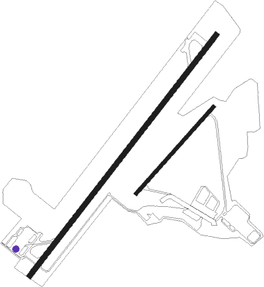
Runway info
Runway 04 / 22  | ||
| length | 2702m (8865ft) | |
| bearing | 42° / 222° | |
| width | 46m (150ft) | |
| surface | asphalt | |
| displ threshold | 151m (495ft) / 152m (499ft) | |
| Runway 05 / 23 | ||
| length | 1032m (3386ft) | |
| bearing | 46° / 226° | |
| width | 30m (100ft) | |
| surface | asphalt | |
| displ threshold | 61m (200ft) / 61m (200ft) | |
Nearby beacons
| code | identifier | dist | bearing | frequency |
|---|---|---|---|---|
| AG | SEMBAWANG (SINGAPORE) NDB | 0.4 | 115° | 325 |
| SEL | SELETAR (SINGAPORE) NDB | 3.3 | 104° | 220 |
| TNG | TENGAH (SINGAPORE) TACAN | 6.5 | 252° | 113.90 |
| PLA | PAYA LEBAR (SINGAPORE) TACAN | 6.7 | 119° | 116.30 |
| PU | PAPA UNIFORM (SINGAPORE) VOR/DME | 7 | 92° | 115.10 |
| JB | JAYBEE (JOHOR BAHRU) NDB | 7.6 | 305° | 400 |
| KK | KONG KONG (JOHOR BAHRU) NDB | 11.8 | 61° | 286 |
| VTK | TEKONG (SINGAPORE) VOR/DME | 12.3 | 93° | 116.50 |
| SJ | SINJON (SINGAPORE) VOR/DME | 12.4 | 169° | 113.50 |
| VJB | JOHOR BAHRU VOR/DME | 17 | 327° | 112.50 |
| JR | JOHOR BAHRU NDB | 17.6 | 327° | 245 |
| BM | BATAM NDB | 25.4 | 136° | 370 |
| BTM | BATAM VOR/DME | 25.7 | 132° | 116 |
| TG | TANJUNG BALAI KARIMUN NDB | 34 | 228° | 410 |
| AP | KLUANG NDB | 48 | 320° | 331 |
| TI | TANJUNG PINANG NDB | 52.3 | 126° | 385 |
| TPG | TANJUNG PINANG VOR/DME | 52.3 | 127° | 114.80 |
| VMR | MERSING (JOHOR BAHRU) VOR/DME | 57.8 | 3° | 116.80 |
Disclaimer
The information on this website is not for real aviation. Use this data with the X-Plane flight simulator only! Data taken with kind consent from X-Plane 12 source code and data files. Content is subject to change without notice.