West Melton
Airport details
| Country | New Zealand |
| State | Canterbury |
| Region | NZ |
| Municipality | Selwyn District |
| Elevation | 304ft (93m) |
| Timezone | GMT +13 |
| Coordinates | -43.47667, 172.39667 |
| Magnetic var | |
| Type | land |
| Available since | X-Plane v10.40 |
| ICAO code | NZWL |
| IATA code | n/a |
| FAA code | n/a |
Communication
| West Melton WEST_MELTON MULT | 119.200 |
Nearby Points of Interest:
Antonio Hall
-St Barnabas Church
-St John of God Halswell
-Papanui Railway Station
-Riccarton House
-Daresbury
-St Andrew's Church
-Chippenham Lodge
-Canterbury Cricket Umpires' Association Pavilion
-Ivey Hall
-Christ's College Big School
-Christchurch West High School
-Peterborough Centre
-Victoria Mansions
-Cranmer Centre
-Registry Building
-St Elmo Courts
-Durham Street Methodist Church
-Worcester Chambers
-Canterbury Club
-Canterbury Provincial Council Buildings
-Wharetiki
-Public Trust Building, Christchurch
-McLean's Mansion
-Chief Post Office, Christchurch
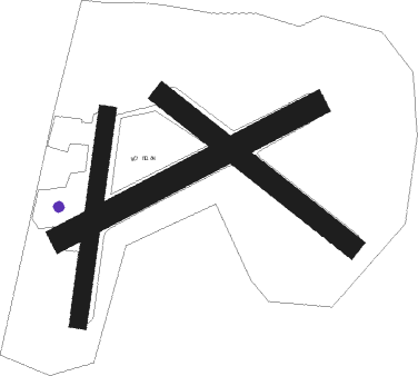
Runway info
Runway 04 / 22  | ||
| length | 608m (1995ft) | |
| bearing | 73° / 253° | |
| width | 16m (52ft) | |
| surface | asphalt | |
| Runway 04C / 22C | ||
| length | 957m (3140ft) | |
| bearing | 73° / 253° | |
| width | 81m (266ft) | |
| surface | grass | |
| Runway 17 / 35 | ||
| length | 696m (2283ft) | |
| bearing | 197° / 17° | |
| width | 58m (190ft) | |
| surface | grass | |
| Runway 11 / 29 | ||
| length | 799m (2621ft) | |
| bearing | 124° / 304° | |
| width | 72m (236ft) | |
| surface | grass | |
Nearby beacons
| code | identifier | dist | bearing | frequency |
|---|---|---|---|---|
| CH | CHRISTCHURCH VOR/DME | 5.3 | 103° | 115.30 |
Disclaimer
The information on this website is not for real aviation. Use this data with the X-Plane flight simulator only! Data taken with kind consent from X-Plane 12 source code and data files. Content is subject to change without notice.