Bridge Pa - Hastings
Airport details
| Country | New Zealand |
| State | Hawke's Bay |
| Region | NZ |
| Municipality | Hastings |
| Elevation | 70ft (21m) |
| Timezone | GMT +12 |
| Coordinates | -39.64667, 176.76694 |
| Magnetic var | |
| Type | land |
| Available since | X-Plane v10.40 |
| ICAO code | NZHS |
| IATA code | n/a |
| FAA code | n/a |
Communication
| HASTINGS NAPIER ATIS | 121.800 |
| HASTINGS CTAF | 119.100 |
| HASTINGS NAPIER Tower | 124.800 |
| HASTINGS NAPIER Tower | 118.100 |
| HASTINGS NAPIER Tower | 129.900 |
Nearby Points of Interest:
Whare Ra
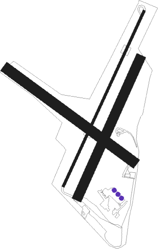
Runway info
Runway 01 / 19  | ||
| length | 1052m (3451ft) | |
| bearing | 36° / 216° | |
| width | 14m (46ft) | |
| surface | asphalt | |
| displ threshold | 93m (305ft) / 33m (108ft) | |
| Runway 11 / 29 | ||
| length | 850m (2789ft) | |
| bearing | 123° / 303° | |
| width | 58m (190ft) | |
| surface | grass | |
| displ threshold | 176m (577ft) / 60m (197ft) | |
| Runway 01R / 19L | ||
| length | 816m (2677ft) | |
| bearing | 35° / 215° | |
| width | 55m (181ft) | |
| surface | grass | |
| displ threshold | 91m (299ft) / 0m (0ft) | |
Nearby beacons
| code | identifier | dist | bearing | frequency |
|---|---|---|---|---|
| NR | NAPIER VOR/DME | 12.5 | 28° | 113.80 |
| AP | TAUPO NDB | 63.1 | 323° | 230 |
Instrument approach procedures
| runway | airway (heading) | route (dist, bearing) |
|---|---|---|
| RW01 | OPAPA (28°) | OPAPA 2600ft |
| RNAV | OPAPA 2600ft FF01 (4mi, 16°) 1650ft MA01 (5mi, 36°) 127ft (8422mi, 283°) 900ft OPAPA (8414mi, 103°) 2600ft | |
| RW19 | NR (208°) | NR 3000ft |
| RNAV | NR 3000ft FF19 (8mi, 204°) 1350ft MA19 (4mi, 216°) 108ft FF01 (6mi, 216°) OPAPA (4mi, 196°) 2600ft |
Disclaimer
The information on this website is not for real aviation. Use this data with the X-Plane flight simulator only! Data taken with kind consent from X-Plane 12 source code and data files. Content is subject to change without notice.