St Paul - St Paul Downtown Holman Fld
Airport details
| Country | United States of America |
| State | Minnesota |
| Region | K3 |
| Airspace | Minneapolis Ctr |
| Municipality | Saint Paul |
| Elevation | 705ft (215m) |
| Timezone | GMT -6 |
| Coordinates | 44.93462, -93.06034 |
| Magnetic var | |
| Type | land |
| Available since | X-Plane v10.40 |
| ICAO code | KSTP |
| IATA code | STP |
| FAA code | STP |
Communication
| St Paul Downtown Holman Fld ATIS | 118.350 |
| St Paul Downtown Holman Fld CTAF | 119.100 |
| St Paul Downtown Holman Fld UNICOM | 122.950 |
| St Paul Downtown Holman Fld Ground Control/Clearance DEL | 121.675 |
| St Paul Downtown Holman Fld Tower | 119.100 |
| St Paul Downtown Holman Fld MINNEAPOLIS Approach/Departure | 121.200 |
Approach frequencies
| ILS-cat-I | RW32 | 111.5 | 18.00mi |
| ILS-cat-I | RW14 | 111.5 | 18.00mi |
| 3° GS | RW32 | 111.5 | 18.00mi |
| 3° GS | RW14 | 111.5 | 18.00mi |
Nearby Points of Interest:
Riverside Hangar
-Holman Field Administration Building
-Giesen–Hauser House
-Colorado Street Bridge
-Riverview Branch Library
-Rau/Strong House
-Saint Matthew's School
-Schornstein Grocery and Saloon
-Euclid View Flats
-Adolf Muench House
-Minnesota Boat Club Boathouse on Raspberry Island
-Wabasha Street Bridge
-Finch, Vanslyck, and McConville Dry Goods Company Building
-Pioneer and Endicott Buildings
-Anthony Yoerg, Sr. House
-Merchants National Bank
-Manhattan Building (Saint Paul, Minnesota)
-Seventh Street Improvement Arches
-Minnesota Building
-Commerce Building
-Saint Paul City Hall and Ramsey County Courthouse
-Harriet Island Pavilion
-Germania Bank Building
-Benjamin Brunson House
-Walsh Building
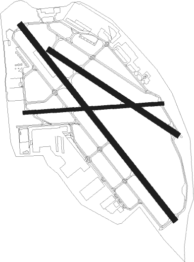
Runway info
Runway 14 / 32  | ||
| length | 1978m (6490ft) | |
| bearing | 137° / 317° | |
| width | 46m (150ft) | |
| surface | asphalt | |
| displ threshold | 105m (344ft) / 116m (381ft) | |
| blast zone | 152m (499ft) / 104m (341ft) | |
| Runway 13 / 31 | ||
| length | 1219m (3999ft) | |
| bearing | 119° / 299° | |
| width | 46m (150ft) | |
| surface | asphalt | |
| blast zone | 0m (0ft) / 35m (115ft) | |
| Runway 9 / 27 | ||
| length | 1107m (3632ft) | |
| bearing | 90° / 270° | |
| width | 30m (100ft) | |
| surface | asphalt | |
| blast zone | 68m (223ft) / 46m (151ft) | |
Nearby beacons
| code | identifier | dist | bearing | frequency |
|---|---|---|---|---|
| MSP | MINNEAPOLIS VOR/DME | 7.8 | 258° | 115.30 |
| FCM | FLYING CLOUD (MINNEAPOLIS VOR/DME | 17.5 | 254° | 117.70 |
| GEP | GOPHER (MINNEAPOLIS) VORTAC | 18.3 | 304° | 117.30 |
| FGT | FARMINGTON VORTAC | 18.9 | 202° | 115.70 |
| RG | REGUE (RED WING) NDB | 26.8 | 129° | 274 |
| PNM | PRINCETON NDB | 44.3 | 319° | 368 |
| FOW | HALFWAY (MORRISTOWN) VOR/DME | 45.8 | 203° | 111.20 |
| ROS | RUSH CITY NDB | 45.9 | 8° | 282 |
| ST | HUSSK (ST CLOUD) NDB | 50.4 | 301° | 342 |
| OW | TONNA (OWATONNA) NDB | 51.8 | 186° | 379 |
| STC | SAINT CLOUD VOR/DME | 56 | 302° | 112.10 |
| MKT | MANKATO VOR/DME | 56.3 | 230° | 110.80 |
| RZN | DME | 60.5 | 38° | 109.40 |
| BXR | BIG DOCTOR (SIREN) NDB | 60.7 | 38° | 203 |
Departure and arrival routes
| Transition altitude | 18000ft |
| Transition level | 18000ft |
| SID end points | distance | outbound heading | |
|---|---|---|---|
| RW09 | |||
| COULT7 | 164mi | 113° | |
| ZMBRO7 | 92mi | 123° | |
| RST1 | 146mi | 164° | |
| ORSKY2 | 255mi | 215° | |
| SCHEP9 | 286mi | 246° | |
| DWN8 | 227mi | 275° | |
| RW13 | |||
| COULT7 | 164mi | 113° | |
| ZMBRO7 | 92mi | 123° | |
| RST1 | 146mi | 164° | |
| ORSKY2 | 255mi | 215° | |
| SCHEP9 | 286mi | 246° | |
| DWN8 | 227mi | 275° | |
| RW14 | |||
| COULT7 | 164mi | 113° | |
| ZMBRO7 | 92mi | 123° | |
| RST1 | 146mi | 164° | |
| ORSKY2 | 255mi | 215° | |
| SCHEP9 | 286mi | 246° | |
| DWN8 | 227mi | 275° | |
| RW27 | |||
| COULT7 | 164mi | 113° | |
| ZMBRO7 | 92mi | 123° | |
| RST1 | 146mi | 164° | |
| ORSKY2 | 255mi | 215° | |
| SCHEP9 | 286mi | 246° | |
| DWN8 | 227mi | 275° | |
| RW32 | |||
| COULT7 | 164mi | 113° | |
| ZMBRO7 | 92mi | 123° | |
| RST1 | 146mi | 164° | |
| ORSKY2 | 255mi | 215° | |
| SCHEP9 | 286mi | 246° | |
| DWN8 | 227mi | 275° | |
| STAR starting points | distance | inbound heading | |
|---|---|---|---|
| ALL | |||
| ENCEE2 | 103.3 | 82° | |
| GEP1 | 56.1 | 142° | |
| AGUDE5 | 30.6 | 254° | |
Instrument approach procedures
| runway | airway (heading) | route (dist, bearing) |
|---|---|---|
| RW14 | GEP (124°) | GEP TEPAW (7mi, 107°) 3000ft |
| RNAV | TEPAW 3000ft MRANN (5mi, 133°) 2900ft KSTP (7mi, 136°) 747ft (5535mi, 116°) 1700ft WHISK (5531mi, 296°) 3000ft WHISK (turn) | |
| RW32 | LDASH (328°) | LDASH FOMRU (5mi, 356°) 3000ft |
| RW32 | PRESS (301°) | PRESS FOMRU (10mi, 285°) 3000ft |
| RNAV | FOMRU 3000ft RULDE (6mi, 317°) 2500ft JOSVU (3mi, 317°) 1460ft KSTP (3mi, 318°) 744ft (5535mi, 116°) 1400ft WHISK (5531mi, 296°) 3000ft WHISK (turn) |
Holding patterns
| STAR name | hold at | type | turn | heading* | altitude | leg | speed limit |
|---|---|---|---|---|---|---|---|
| AGUDE5 | BEERI | VHF | right | 127 (307)° | 1.0min timed | ICAO rules | |
| ENCEE2 | WOOOD | VHF | left | 251 (71)° | < 17999ft | DME 10.0mi | ICAO rules |
| GEP1 | GOLLF | VHF | left | 333 (153)° | < 17999ft | 1.0min timed | ICAO rules |
| TWOLF3 | TWOLF | VHF | left | 178 (358)° | < 17999ft | 1.0min timed | ICAO rules |
| *) magnetic outbound (inbound) holding course | |||||||
Disclaimer
The information on this website is not for real aviation. Use this data with the X-Plane flight simulator only! Data taken with kind consent from X-Plane 12 source code and data files. Content is subject to change without notice.