Greenville - Pitt-greenville
Airport details
| Country | United States of America |
| State | North Carolina |
| Region | K7 |
| Airspace | Washington Ctr |
| Municipality | Greenville |
| Elevation | 25ft (8m) |
| Timezone | GMT -5 |
| Coordinates | 35.63263, -77.38284 |
| Magnetic var | |
| Type | land |
| Available since | X-Plane v10.40 |
| ICAO code | KPGV |
| IATA code | PGV |
| FAA code | PGV |
Communication
| Pitt-Greenville AWOS 3 | 128.425 |
| Pitt-Greenville CTAF/UNICOM | 122.800 |
Approach frequencies
| ILS-cat-I | RW20 | 110.7 | 18.00mi |
| 3° GS | RW20 | 110.7 | 18.00mi |
Nearby Points of Interest:
E. B. Ficklen House
-James L. Fleming House
-Pitt County Courthouse
-Jesse R. Moye House
-United States Post Office
-Greenville Commercial Historic District
-Robert Lee Humber House
-Dickinson Avenue Historic District
-Jones-Lee House
-Greenville Tobacco Warehouse Historic District
-Skinnerville-Greenville Heights Historic District
-Cox-Ange House
-William H. Long House
-Grimesland Plantation
-Robersonville Primitive Baptist Church
-First Christian Church
-Trinity Episcopal Church
-St. John's Episcopal Church
-Bank of Washington, West End Branch
-Beaufort County Courthouse
-North Market Street Historic District
-Bowers-Tripp House
-Greene County Courthouse
-Fort Neoheroka
-Skewarkey Primitive Baptist Church
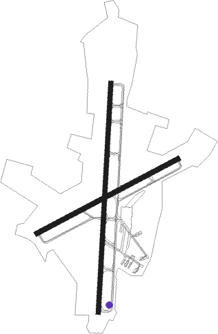
Runway info
Runway 2 / 20  | ||
| length | 2194m (7198ft) | |
| bearing | 9° / 189° | |
| width | 46m (150ft) | |
| surface | asphalt | |
| displ threshold | 82m (269ft) / 0m (0ft) | |
| Runway 8 / 26 | ||
| length | 1522m (4993ft) | |
| bearing | 71° / 251° | |
| width | 46m (150ft) | |
| surface | asphalt | |
Nearby beacons
| code | identifier | dist | bearing | frequency |
|---|---|---|---|---|
| AQE | ALWOOD (GREENVILLE) NDB | 4.4 | 8° | 230 |
| RNW | CHOCOWINITY NDB | 15.3 | 114° | 388 |
| ISO | KINSTON VORTAC | 17.9 | 214° | 109.60 |
| TYI | TAR RIVER (ROCKY MOUNT) VORTAC | 25.9 | 317° | 117.80 |
| IS | STALS (KINSTON) NDB | 27.9 | 219° | 276 |
| GSB | SEYMOUR JOHNSON TACAN | 33.8 | 243° | 116.50 |
| EWN | NEW BERN VOR/DME | 37.4 | 149° | 113.60 |
| EW | KAFTI (NEW BERN) NDB | 39.5 | 154° | 362 |
| NKT | CHERRY POINT TACAN | 50.4 | 145° | 112.80 |
| CVI | COFIELD VORTAC | 50.9 | 35° | 114.60 |
| OA | ELLAS (JACKSONVILLE) NDB | 55.2 | 200° | 261 |
| NCA | NEW RIVER TACAN | 55.6 | 184° | 115.40 |
| CTZ | CLINTON NDB | 62.1 | 236° | 412 |
Instrument approach procedures
| runway | airway (heading) | route (dist, bearing) |
|---|---|---|
| RW02 | ISO (34°) | ISO BOWBO (8mi, 62°) 2400ft |
| RNAV | BOWBO 2400ft ARCCO (6mi, 9°) 1600ft JONGO (3mi, 9°) 760ft KPGV (2mi, 12°) 78ft (4791mi, 115°) 403ft KENIR (4791mi, 295°) 2100ft KENIR (turn) | |
| RW08 | WIBID (71°) | WIBID 2700ft |
| RNAV | WIBID 2700ft EXINE (6mi, 71°) 1800ft RADIE (3mi, 71°) 780ft KPGV (3mi, 74°) 66ft AVUTE (5mi, 69°) 3000ft KENIR (13mi, 342°) KENIR (turn) | |
| RW20 | KENIR (189°) | KENIR 2100ft |
| RNAV | KENIR 2100ft EVAXY (10mi, 189°) 1400ft TROTH (3mi, 189°) 540ft KPGV (2mi, 186°) 76ft (4791mi, 115°) 230ft BOWBO (4791mi, 295°) 3100ft BOWBO (turn) | |
| RW26 | KENIR (189°) | KENIR EGEKE (8mi, 122°) 3000ft TAVIE (5mi, 152°) 2500ft |
| RW26 | WEMOX (246°) | WEMOX TAVIE (8mi, 239°) 2500ft |
| RNAV | TAVIE 2500ft AVUTE (6mi, 251°) 1700ft KPGV (5mi, 249°) 68ft EXINE (6mi, 252°) FESBA (12mi, 332°) KENIR (13mi, 71°) 3000ft KENIR (turn) |
Disclaimer
The information on this website is not for real aviation. Use this data with the X-Plane flight simulator only! Data taken with kind consent from X-Plane 12 source code and data files. Content is subject to change without notice.