Cincinnati - Cincinnati Muni Lunken Fld
Airport details
| Country | United States of America |
| State | Ohio |
| Region | K5 |
| Airspace | Indianapolis Ctr |
| Municipality | Cincinnati |
| Elevation | 479ft (146m) |
| Timezone | GMT -5 |
| Coordinates | 39.10333, -84.41861 |
| Magnetic var | |
| Type | land |
| Available since | X-Plane v10.40 |
| ICAO code | KLUK |
| IATA code | LUK |
| FAA code | LUK |
Communication
| Cincinnati Muni Lunken Fld ATIS | 120.250 |
| Cincinnati Muni Lunken Fld UNICOM | 122.950 |
| Cincinnati Muni Lunken Fld CTAF | 118.700 |
| Cincinnati Muni Lunken Fld Clearance DEL | 124.900 |
| Cincinnati Muni Lunken Fld Ground Control | 121.900 |
| Cincinnati Muni Lunken Fld LUNKEN Tower | 118.700 |
| Cincinnati Muni Lunken Fld LUNKEN Tower | 133.925 |
| Cincinnati Muni Lunken Fld Approach/Departure | 121.000 |
Approach frequencies
| ILS-cat-I | RW21L | 110.9 | 18.00mi |
| 3° GS | RW21L | 110.9 | 18.00mi |
Nearby Points of Interest:
L.B. Robb Drugstore
-Clauder's Pharmacy
-Kestler Building
-Mardot Antique Shop
-McKinley School
-August Bepler House
-Spencer Township Hall
-Stites House
-Landt Building
-Bates Building
-Norwell Residence
-Stephen Decker Rowhouse
-LuNeack House
-Houston House
-Clough Creek and Sand Ridge Archeological District
-Police Station No. 6
-Bernheim House
-Lillybanks
-George Hoadley Jr. House
-John Henry Weston House
-Miller-Leuser Log House
-La Tosca Flats
-St. Rose Church
-Turpin Site
-Peters-Kupferschmid House
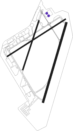
Runway info
Runway 3R / 21L  | ||
| length | 1862m (6109ft) | |
| bearing | 26° / 206° | |
| width | 46m (151ft) | |
| surface | asphalt | |
| Runway 7 / 25 | ||
| length | 1565m (5135ft) | |
| bearing | 68° / 248° | |
| width | 30m (98ft) | |
| surface | asphalt | |
| displ threshold | 134m (440ft) / 0m (0ft) | |
| Runway 3L / 21R | ||
| length | 1160m (3806ft) | |
| bearing | 28° / 208° | |
| width | 30m (98ft) | |
| surface | asphalt | |
Nearby beacons
| code | identifier | dist | bearing | frequency |
|---|---|---|---|---|
| PWF | SPORTYS (BATAVIA) NDB | 9.6 | 97° | 245 |
| CVG | CINCINNATI VORTAC | 14.2 | 253° | 117.30 |
| HKF | HOOK FIELD (MIDDLETOWN) NDB | 23.7 | 356° | 239 |
| FLM | FALMOUTH VOR/DME | 27.7 | 167° | 117 |
| MW | ONIDA (MIDDLETOWN) NDB | 28.8 | 11° | 223 |
| HW | CUBLA (WILMINGTON) NDB | 29.3 | 65° | 299 |
| MXQ | MIDWEST (WILMINGTON) VOR/DME | 34.7 | 62° | 112.90 |
| IL | AIRBO (WILMINGTON) NDB | 39.3 | 60° | 407 |
| HLB | BATESVILLE NDB | 41.7 | 286° | 254 |
| RID | RICHMOND VOR/DME | 43.7 | 327° | 110.60 |
| AT | BRUNY (DAYTON) NDB | 44.8 | 6° | 315 |
| FFO | PATTERSON (DAYTON) TACAN | 46.1 | 27° | 115.20 |
| SGH | DME | 51.4 | 38° | 113.20 |
| XSF | SPRINGFIELD TACAN | 51.6 | 38° | 133.80 |
| SQ | PNTHR (CONNERSVILLE) NDB | 52.2 | 313° | 227 |
| DQN | DAYTON VOR/DME | 54.8 | 1° | 114.50 |
| GN | BRIDL (LEXINGTON) NDB | 58.9 | 185° | 340 |
| FFT | FRANKFORT VOR | 59.8 | 208° | 109.40 |
| UWL | NEW CASTLE NDB | 62.5 | 311° | 385 |
Departure and arrival routes
| Transition altitude | 18000ft |
| Transition level | 18000ft |
| SID end points | distance | outbound heading | |
|---|---|---|---|
| RW03L | |||
| ROCKT1 | 91mi | 68° | |
| RW03R | |||
| ROCKT1 | 91mi | 68° | |
| RW07 | |||
| ROCKT1 | 91mi | 68° | |
| RW21L | |||
| ROCKT1 | 91mi | 68° | |
| RW21R | |||
| ROCKT1 | 91mi | 68° | |
| RW25 | |||
| ROCKT1 | 91mi | 68° | |
| STAR starting points | distance | inbound heading | |
|---|---|---|---|
| ALL | |||
| SHB6 | 55.4 | 111° | |
| CINCE9 | 28.7 | 223° | |
| HEDEE4 | 42.8 | 229° | |
| HARDU5 | 86.7 | 331° | |
Instrument approach procedures
| runway | airway (heading) | route (dist, bearing) |
|---|---|---|
| RW03R | CUCJU (45°) | CUCJU SHILA (10mi, 63°) 2500ft |
| RW03R | FLM (347°) | FLM LODLL (10mi, 336°) 2700ft SHILA (10mi, 319°) 2500ft |
| RNAV | SHILA 2500ft WONAN (5mi, 26°) 2100ft ZUGMI (2mi, 26°) 1480ft KLUK (4mi, 23°) 528ft (5145mi, 115°) 883ft KUYEY (5141mi, 295°) 2600ft KUYEY (turn) | |
| RW21L | BOSTR (303°) | BOSTR KUYEY (27mi, 329°) 2600ft KUYEY (turn) 2600ft |
| RW21L | MOAKS (229°) | MOAKS KUYEY (6mi, 267°) 2600ft |
| RNAV | KUYEY 2600ft SIYOR (7mi, 206°) 2000ft YACUK (2mi, 206°) 1460ft KLUK (3mi, 210°) 514ft (5145mi, 115°) 756ft WONAN (5147mi, 295°) CALIF (8mi, 119°) 2500ft CALIF (turn) 2600ft | |
| RW25 | BOSTR (303°) | BOSTR HIGUP (16mi, 351°) 2400ft HINIM (5mi, 296°) 2400ft |
| RW25 | BRNIE (228°) | BRNIE HINIM (5mi, 174°) 2400ft |
| RW25 | HINIM (247°) | HINIM 2400ft |
| RNAV | HINIM 2400ft CUXON (6mi, 248°) 1900ft ZEDIK (1mi, 248°) 1480ft KLUK (3mi, 245°) 530ft (5145mi, 115°) 875ft JULVU (5150mi, 295°) SHILA (7mi, 166°) CALIF (9mi, 92°) 2500ft CALIF (turn) 2600ft |
Holding patterns
| STAR name | hold at | type | turn | heading* | altitude | leg | speed limit |
|---|---|---|---|---|---|---|---|
| CINCE9 | BOWRR | VHF | left | 68 (248)° | 1.0min timed | ICAO rules | |
| CINCE9 | HEDEE | VHF | left | 68 (248)° | 1.0min timed | ICAO rules | |
| CINCE9 | TIGRR | VHF | left | 51 (231)° | 1.0min timed | 230 | |
| HARDU5 | CHEDA | VHF | left | 191 (11)° | 1.5min timed | ICAO rules | |
| HARDU5 | HARDU | VHF | right | 154 (334)° | DME 10.0mi | ICAO rules | |
| SHB6 | CEGRM | VHF | left | 292 (112)° | < 17999ft | 1.0min timed | 230 |
| SHB6 | VHP | NDB | left | 272 (92)° | 1.0min timed | ICAO rules | |
| *) magnetic outbound (inbound) holding course | |||||||
Disclaimer
The information on this website is not for real aviation. Use this data with the X-Plane flight simulator only! Data taken with kind consent from X-Plane 12 source code and data files. Content is subject to change without notice.