Nairobi - Nairobi Wilson
Airport details
| Country | Kenya |
| State | Nairobi Province |
| Region | HK |
| Airspace | Nairobi Ctr |
| Municipality | Nairobi |
| Elevation | 5544ft (1690m) |
| Timezone | GMT +3 |
| Coordinates | -1.32452, 36.80539 |
| Magnetic var | |
| Type | land |
| Available since | X-Plane v10.40 |
| ICAO code | HKNW |
| IATA code | WIL |
| FAA code | n/a |
Communication
| Nairobi Wilson WILSON Tower | 118.100 |
Nearby Points of Interest:
Olorgesailie
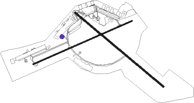
Runway info
Runway 14 / 32  | ||
| length | 1555m (5102ft) | |
| bearing | 135° / 315° | |
| width | 23m (75ft) | |
| surface | asphalt | |
| displ threshold | 199m (653ft) / 0m (0ft) | |
| Runway 07 / 25 | ||
| length | 1457m (4780ft) | |
| bearing | 71° / 251° | |
| width | 21m (70ft) | |
| surface | asphalt | |
Nearby beacons
| code | identifier | dist | bearing | frequency |
|---|---|---|---|---|
| NO | NAIROBI NDB | 4.2 | 125° | 278 |
| NV | NAVEX VOR/DME | 9 | 81° | 113.10 |
| GV | NGONG VOR | 10.9 | 247° | 115.90 |
| TH | ATHI RIVER (NAIROBI) NDB | 16.7 | 130° | 329 |
| TV | STONY VOR | 16.8 | 130° | 115.50 |
Departure and arrival routes
| Transition altitude | 9000ft |
| SID end points | distance | outbound heading | |
|---|---|---|---|
| RW14 | |||
| LABA1A | 12mi | 312° | |
Disclaimer
The information on this website is not for real aviation. Use this data with the X-Plane flight simulator only! Data taken with kind consent from X-Plane 12 source code and data files. Content is subject to change without notice.