Linton-on-ouse - Raf Linton On Ouse
Airport details
| Country | United Kingdom |
| State | England |
| Region | EG |
| Airspace | London Ctr |
| Municipality | Hambleton |
| Elevation | 53ft (16m) |
| Timezone | GMT +0 |
| Coordinates | 54.04398, -1.25694 |
| Magnetic var | |
| Type | land |
| Available since | X-Plane v10.40 |
| ICAO code | EGXU |
| IATA code | HRT |
| FAA code | n/a |
Communication
| RAF Linton On Ouse Linton Ground | 122.100 |
| RAF Linton On Ouse Linton Tower | 129.350 |
| RAF Linton On Ouse Linton Approach | 118.550 |
| RAF Linton On Ouse Linton Departure | 123.300 |
Nearby Points of Interest:
Allerton Castle
-Sutton Park
-Ribston Hall
-St Robert's Cave medieval hermitage, 90m north of Plumpton Mill Farm
-Ingram House
-Bootham Park Hospital
-St Marys Tower
-Nos 25,27,29 And 31 (Old Town Hall) With Additional Range On Right Return
-King's Manor
-York Library
-North Eastern Railway Company War Memorial
-Lendal Tower
-Old Palace
-York Assembly Rooms
-Knaresborough Viaduct
-Grays Court, York
-Micklegate House And Attached Railings And Lamp Brackets
-The Norman House
-85, 87 And 89, Micklegate
-Mulberry Hall
-Garforth House And Railings Attached At Front, Garden Wall Attached At Rear
-73, 75 And 77, Low Petergate
-30 and 32 Goodramgate and 11 and 12 College Street
-St John's Church, Micklegate, York
-41, 43 And 45, Goodramgate
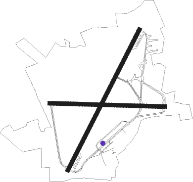
Runway info
Runway 03 / 21  | ||
| length | 1829m (6001ft) | |
| bearing | 46° / 226° | |
| width | 46m (151ft) | |
| surface | asphalt | |
| displ threshold | 154m (505ft) / 0m (0ft) | |
| blast zone | 20m (66ft) / 34m (112ft) | |
| Runway 10 / 28 | ||
| length | 1334m (4377ft) | |
| bearing | 94° / 274° | |
| width | 46m (151ft) | |
| surface | asphalt | |
| displ threshold | 182m (597ft) / 0m (0ft) | |
| blast zone | 28m (92ft) / 55m (180ft) | |
Nearby beacons
| code | identifier | dist | bearing | frequency |
|---|---|---|---|---|
| SBL | SHERBURN-IN-ELMET NDB | 15.3 | 169° | 323 |
| LBA | LEEDS BRADFORD NDB | 17.6 | 246° | 402 |
| LEE | LEEMING TACAN | 18.1 | 312° | 112.60 |
| TD | TEESSIDE INTL NDB | 31.1 | 352° | 347 |
| POL | POLE HILL VOR/DME | 34.9 | 250° | 112.10 |
| FNY | DONCASTER SHEFFIELD NDB | 35.3 | 156° | 338 |
| KIM | HUMBERSIDE NDB | 42.6 | 117° | 365 |
| GAM | GAMSTON VOR/DME | 47.1 | 158° | 112.80 |
| WAD | WADDINGTON TACAN | 58.8 | 140° | 117.10 |
| TNT | TRENT VOR/DME | 61.2 | 203° | 115.70 |
| NEW | DME | 61.6 | 336° | 114.25 |
Disclaimer
The information on this website is not for real aviation. Use this data with the X-Plane flight simulator only! Data taken with kind consent from X-Plane 12 source code and data files. Content is subject to change without notice.