Peterborough - Peterborough Sibson
Airport details
| Country | United Kingdom |
| State | England |
| Region | EG |
| Airspace | London Ctr |
| Municipality | Cambridgeshire |
| Elevation | 126ft (38m) |
| Timezone | GMT +0 |
| Coordinates | 52.55583, -0.38633 |
| Magnetic var | |
| Type | land |
| Available since | X-Plane v10.40 |
| ICAO code | EGSP |
| IATA code | n/a |
| FAA code | n/a |
Communication
| Peterborough Sibson Sibson Radio | 120.325 |
Nearby Points of Interest:
Elton Hall
-Wansford Pasture
-Southorpe Paddock
-Milton Hall
-Southorpe Meadow
-Walcot Hall
-Ufford Hall
-Thorpe Hall
-Oundle railway station
-Woodcroft Castle
-Old Guild Hall
-Peterscourt
-St Leonard's Priory, Stamford
-Barnwell Castle
-Barnwell Manor
-Stamford Town Hall
-Kings Mill
-St Paul's Church, Stamford
-Browne's Hospital
-Town Hall
-Deene Park
-Lyveden New Bield
-RAF North Luffenham
-Woodwalton Fen
-Drayton House
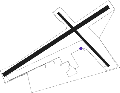
Runway info
Runway 6 / 24  | ||
| length | 938m (3077ft) | |
| bearing | 72° / 252° | |
| width | 30m (98ft) | |
| surface | grass | |
| displ threshold | 470m (1542ft) / 259m (850ft) | |
| Runway 15 / 33 | ||
| length | 552m (1811ft) | |
| bearing | 127° / 307° | |
| width | 18m (59ft) | |
| surface | grass | |
| displ threshold | 0m (0ft) / 127m (417ft) | |
Nearby beacons
| code | identifier | dist | bearing | frequency |
|---|---|---|---|---|
| WIT | WITTERING TACAN | 5.1 | 295° | 117.60 |
| LE | LEICESTER NDB | 23.8 | 274° | 383 |
| CIT | CRANFIELD NDB | 26.3 | 202° | 850 |
| CWL | CRANWELL NDB | 28.5 | 348° | 423 |
| CWZ | CRANWELL TACAN | 28.6 | 348° | 117.40 |
| CAM | CAMBRIDGE NDB | 29.4 | 121° | 332 |
| CGY | CONINGSBY TACAN | 33 | 22° | 111.10 |
| EME | EAST MIDLANDS NDB | 33.7 | 289° | 353 |
| MLD | MILDENHALL TACAN | 34 | 102° | 115.90 |
| DTY | DAVENTRY VOR/DME | 34.9 | 243° | 116.40 |
| MAM | MARHAM TACAN | 34.9 | 85° | 108.70 |
| LKH | LAKENHEATH TACAN | 35.3 | 99° | 110.20 |
| WAD | WADDINGTON TACAN | 36.9 | 347° | 117.10 |
| BKY | BARKWAY VOR/DME | 37.7 | 142° | 116.25 |
| LUT | LUTON NDB | 40 | 169° | 345 |
| WCO | WESTCOTT NDB | 47.2 | 219° | 335 |
| GAM | GAMSTON VOR/DME | 48 | 322° | 112.80 |
| BPK | BROOKMANS PARK VOR/DME | 49.4 | 161° | 117.50 |
| HEN | HENTON NDB | 50 | 207° | 433 |
| BNN | BOVINGDON VOR/DME | 50.1 | 191° | 113.75 |
| WTZ | WATTISHAM TACAN | 55.2 | 108° | 109.30 |
| OX | OXFORD NDB | 55.4 | 232° | 367 |
| CHT | CHILTERN NDB | 56.2 | 188° | 277 |
| LAM | LAMBOURNE VOR/DME | 58.1 | 149° | 115.60 |
| FNY | DONCASTER SHEFFIELD NDB | 59.5 | 326° | 338 |
| NWI | NORWICH NDB | 61.6 | 86° | 342 |
| BSO | BENSON TACAN | 62.3 | 217° | 110 |
| CLN | CLACTON VOR/DME | 70.6 | 115° | 114.55 |
| SND | SOUTHEND NDB | 71.2 | 132° | 362 |
Disclaimer
The information on this website is not for real aviation. Use this data with the X-Plane flight simulator only! Data taken with kind consent from X-Plane 12 source code and data files. Content is subject to change without notice.