Stornoway
Airport details
| Country | United Kingdom |
| State | Scotland |
| Region | EG |
| Airspace | Scottish Ctr |
| Municipality | Western Isles |
| Elevation | 21ft (6m) |
| Timezone | GMT +0 |
| Coordinates | 58.21556, -6.33111 |
| Magnetic var | |
| Type | land |
| Available since | X-Plane v10.40 |
| ICAO code | EGPO |
| IATA code | SYY |
| FAA code | n/a |
Communication
| Stornoway Stornoway Information | 115.100 |
| Stornoway Stornoway Tower | 119.480 |
Approach frequencies
| LOC | RW36 | 110.9 | 18.00mi |
| LOC | RW18 | 110.9 | 18.00mi |
Nearby Points of Interest:
Dun Baravat, Lewis
-Dun Bharabhat, Great Bernera
-Airigh a'Sguir,beehive shielings
-Dùn Èistean
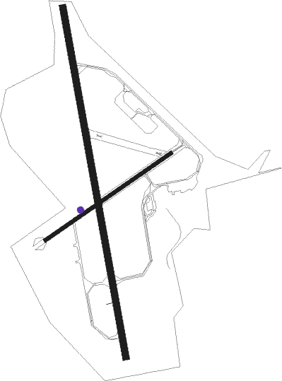
Runway info
Runway 18 / 36  | ||
| length | 2315m (7595ft) | |
| bearing | 169° / 349° | |
| width | 46m (151ft) | |
| surface | asphalt | |
| displ threshold | 113m (371ft) / 114m (374ft) | |
| Runway 06 / 24 | ||
| length | 996m (3268ft) | |
| bearing | 73° / 253° | |
| width | 23m (75ft) | |
| surface | asphalt | |
| blast zone | 96m (315ft) / 0m (0ft) | |
Nearby beacons
| code | identifier | dist | bearing | frequency |
|---|---|---|---|---|
| SAY | STORNOWAY NDB | 0 | 92° | 431 |
| STN | STORNOWAY VOR/DME | 4.7 | 93° | 115.10 |
Disclaimer
The information on this website is not for real aviation. Use this data with the X-Plane flight simulator only! Data taken with kind consent from X-Plane 12 source code and data files. Content is subject to change without notice.