Manchester / Salford - Manchester Barton
Airport details
| Country | United Kingdom |
| State | England |
| Region | EG |
| Airspace | London Ctr |
| Municipality | Salford |
| Elevation | 73ft (22m) |
| Timezone | GMT +0 |
| Coordinates | 53.46881, -2.39403 |
| Magnetic var | |
| Type | land |
| Available since | X-Plane v10.40 |
| ICAO code | EGCB |
| IATA code | n/a |
| FAA code | n/a |
Communication
| Manchester Barton Barton AFIS | 120.250 |
Nearby Points of Interest:
The Grapes
-Worsley Court House
-Worsley Old Hall
-Boothstown Mines Rescue Station
-St George's Church, Carrington
-Astley Green Colliery Museum
-Morleys Hall
-Wardley Hall
-Garrett Hall
-Damhouse
-Buile Hill Park
-Holcroft Hall
-St Ann's, Stretford
-Tyldesley Top Chapel
-Leigh Spinners
-Trafford Town Hall
-St Anne's Church, Hindsford
-Rixton Clay Pits
-Hulme Barracks
-Kearsley Mill
-Leigh Town Hall
-British Muslim Heritage Centre
-Church of St George, Chester Road, Hulme
-Manchester Liverpool Road railway station
-1830 warehouse, Liverpool Road railway station
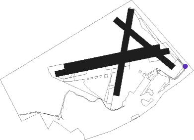
Runway info
Runway 08R / 26L  | ||
| length | 626m (2054ft) | |
| bearing | 86° / 266° | |
| width | 32m (105ft) | |
| surface | grass | |
| Runway 08L / 26R | ||
| length | 523m (1716ft) | |
| bearing | 86° / 266° | |
| width | 30m (98ft) | |
| surface | grass | |
| Runway 14 / 32 | ||
| length | 398m (1306ft) | |
| bearing | 120° / 300° | |
| width | 32m (105ft) | |
| surface | grass | |
| Runway 02 / 20 | ||
| length | 464m (1522ft) | |
| bearing | 23° / 203° | |
| width | 32m (105ft) | |
| surface | grass | |
Nearby beacons
| code | identifier | dist | bearing | frequency |
|---|---|---|---|---|
| MCT | MANCHESTER VOR/DME | 8.2 | 130° | 113.55 |
| LPL | LIVERPOOL NDB | 14.1 | 249° | 349 |
| WHI | WHITEGATE NDB | 18.9 | 219° | 368 |
| POL | POLE HILL VOR/DME | 19.4 | 47° | 112.10 |
| WTN | WARTON NDB | 23.5 | 302° | 337 |
| WTN | WARTON TACAN | 23.9 | 299° | 113.20 |
| WAL | WALLASEY VOR/DME | 26.8 | 264° | 114.10 |
| HAW | HAWARDEN NDB | 27.2 | 244° | 340 |
| BPL | BLACKPOOL NDB | 29 | 296° | 318 |
| LBA | LEEDS BRADFORD NDB | 35.5 | 62° | 402 |
| TNT | TRENT VOR/DME | 36 | 120° | 115.70 |
| SWB | SHAWBURY VOR/DME | 41.4 | 202° | 116.80 |
| TNL | TATENHILL NDB | 45.3 | 136° | 327 |
| WL | BARROW (WALNEY ISLAND) NDB | 50.1 | 307° | 385 |
| EMW | EAST MIDLANDS NDB | 51.2 | 124° | 393 |
| WPL | WELSHPOOL NDB | 57.3 | 222° | 323 |
| WBA | WOLVERHAMPTON NDB | 57.4 | 172° | 356 |
| WOL | DME | 57.4 | 172° | 108.60 |
| LEE | LEEMING TACAN | 58.2 | 46° | 112.60 |
Disclaimer
The information on this website is not for real aviation. Use this data with the X-Plane flight simulator only! Data taken with kind consent from X-Plane 12 source code and data files. Content is subject to change without notice.