Goolwa
Airport details
| Country | Australia |
| State | South Australia |
| Region | YM |
| Airspace | Melbourne Ctr |
| Municipality | Goolwa |
| Elevation | 104ft (32m) |
| Timezone | GMT +10.5 |
| Coordinates | -35.48195, 138.75139 |
| Magnetic var | |
| Type | land |
| Available since | X-Plane v10.40 |
| ICAO code | YGWA |
| IATA code | n/a |
| FAA code | n/a |
Communication
| Goolwa CTAF | 126.950 |
Nearby Points of Interest:
Mount Breckan
-Lake Alexandrina
-Clarendon Weir
-Happy Valley Reservoir
-Benacre
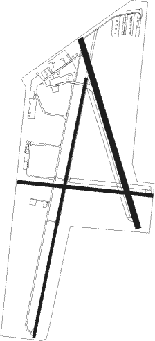
Runway info
Runway 01 / 19  | ||
| length | 1309m (4295ft) | |
| bearing | 19° / 199° | |
| width | 12m (39ft) | |
| surface | asphalt | |
| displ threshold | 126m (413ft) / 0m (0ft) | |
| Runway 16 / 34 | ||
| length | 967m (3173ft) | |
| bearing | 165° / 345° | |
| width | 27m (87ft) | |
| surface | grass | |
| Runway 09 / 27 | ||
| length | 664m (2178ft) | |
| bearing | 98° / 278° | |
| width | 18m (59ft) | |
| surface | grass | |
Nearby beacons
| code | identifier | dist | bearing | frequency |
|---|---|---|---|---|
| AD | ADELAIDE VOR/DME | 34 | 337° | 116.40 |
| PF | PARAFIELD (ADELAIDE) NDB | 41.5 | 350° | 416 |
| EDN | EDINBURGH (ADELAIDE) TACAN | 47.1 | 350° | 110.30 |
Disclaimer
The information on this website is not for real aviation. Use this data with the X-Plane flight simulator only! Data taken with kind consent from X-Plane 12 source code and data files. Content is subject to change without notice.