Sandusky - Sandusky City
Airport details
| Country | United States of America |
| State | Michigan |
| Region | K5 |
| Airspace | Cleveland Ctr |
| Municipality | Custer Township |
| Elevation | 774ft (236m) |
| Timezone | GMT -5 |
| Coordinates | 43.45563, -82.84178 |
| Magnetic var | |
| Type | land |
| Available since | X-Plane v10.40 |
| ICAO code | Y83 |
| IATA code | n/a |
| FAA code | n/a |
Communication
| Sandusky City CTAF/UNICOM | 122.800 |
Nearby Points of Interest:
Loop-Harrison Mansion
-Port Sanilac Masonic and Town Hall
-Sanilac Petroglyphs Historic State Park
-W.R. Roach Cannery Warehouse and Office Building
-First Presbyterian Church
-William Reuben Nims House
-John L. Fead House
-Cadillac House
-Charles H. Moore – Albert E. Sleeper House
-Jeddo Road–South Branch Mill Creek Drain Bridge
-Thomas and Margaret Spencer Matthews Farm
-James McColl House
-Pioneer State Bank No. 36
-Albert E. Sleeper House
-Randall House
-Younge Site
-Tuscola County Courthouse
-Trinity Episcopal Church
-Frank Murphy Birthplace
-Grice House Museum
-Charles Palmer House
-James F. Fairweather–Jacob C. Lamb House
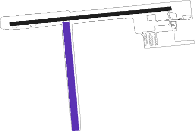
Runway info
Runway 9 / 27  | ||
| length | 1068m (3504ft) | |
| bearing | 89° / 269° | |
| width | 23m (75ft) | |
| surface | asphalt | |
| Runway 18 / 36 | ||
| length | 702m (2303ft) | |
| bearing | 179° / 359° | |
| width | 46m (150ft) | |
| surface | grass | |
Nearby beacons
| code | identifier | dist | bearing | frequency |
|---|---|---|---|---|
| ECK | PECK TACAN | 13.1 | 148° | 114 |
| PH | PHURN (PORT HURON) NDB | 38.3 | 158° | 332 |
| FNT | FLINT VORTAC | 49.3 | 242° | 116.90 |
| MTC | SELFRIDGE (MOUNT CLEMENS) TACAN | 50.6 | 179° | 133.70 |
| PSI | DME | 54.5 | 222° | 111 |
| ASP | SABLE (OSCODA) DME | 64.2 | 331° | 116.10 |
Disclaimer
The information on this website is not for real aviation. Use this data with the X-Plane flight simulator only! Data taken with kind consent from X-Plane 12 source code and data files. Content is subject to change without notice.