Springfield - Springfield Muni
Airport details
| Country | United States of America |
| State | South Dakota |
| Region | K3 |
| Airspace | Minneapolis Ctr |
| Municipality | Springfield |
| Elevation | 1324ft (404m) |
| Timezone | GMT -6 |
| Coordinates | 42.88112, -97.90163 |
| Magnetic var | |
| Type | land |
| Available since | X-Plane v10.40 |
| ICAO code | Y03 |
| IATA code | n/a |
| FAA code | Y03 |
Communication
| Springfield Muni CTAF | 122.900 |
Nearby Points of Interest:
Congregational Church and Manse
-Church of Our Most Merciful Saviour
-Bon Homme County Courthouse
-ZCBJ Hall
-John Frydrych Farmstead
-Old St. Wenceslaus Catholic Parish House
-St. Wenceslaus Catholic Church and Parish House
-Mathias Merkwan Rubblestone Barn
-Ponca Tribal Self-Help Community Building Historic District
-Knox County Courthouse
-Rad Sladkovsky
-Wagner House
-St. Andrew's Episcopal Church
-Z.C.B.J. Opera House
-Methodist Episcopal Church
-Utica Fire and City Hall
-DeJong House
-Argo Hotel
-Pospeshil Theatre
-Human Services Center
-Holy Fellowship Episcopal Church (Greenwood, South Dakota)
-Dr. John Trierweiler House
-Harold A. (H.A.) Doyle House
-Dr. B.M. Banton House
-Winnetoon Jail
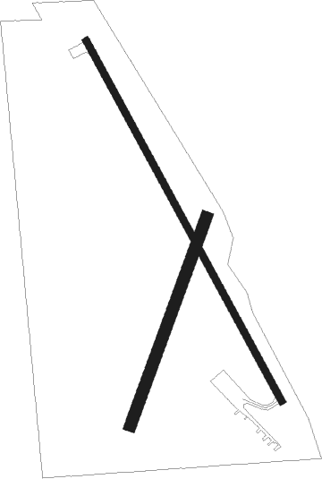
Runway info
Runway 15 / 33  | ||
| length | 1067m (3501ft) | |
| bearing | 149° / 329° | |
| width | 18m (60ft) | |
| surface | asphalt | |
| Runway 01 / 19 | ||
| length | 575m (1886ft) | |
| bearing | 32° / 212° | |
| width | 30m (100ft) | |
| surface | grass | |
Nearby beacons
| code | identifier | dist | bearing | frequency |
|---|---|---|---|---|
| AGZ | WAGNER NDB | 20.3 | 295° | 392 |
| YKN | YANKTON VOR/DME | 22.8 | 86° | 111.40 |
| YK | CAGUR (YANKTON) NDB | 26.4 | 94° | 347 |
| ONL | O'NEILL VORTAC | 42.5 | 242° | 113.90 |
| MHE | MITCHELL VOR/DME | 54.1 | 351° | 109.20 |
| OFK | NORFOLK VOR/DME | 57.4 | 152° | 109.60 |
Disclaimer
The information on this website is not for real aviation. Use this data with the X-Plane flight simulator only! Data taken with kind consent from X-Plane 12 source code and data files. Content is subject to change without notice.