Raymondville - Flying W
Airport details
| Country | United States of America |
| State | Texas |
| Region | |
| Airspace | Houston Oceanic Ctr |
| Municipality | Willacy County |
| Elevation | 29ft (9m) |
| Timezone | GMT -6 |
| Coordinates | 26.45052, -97.79721 |
| Magnetic var | |
| Type | land |
| Available since | X-Plane v10.40 |
| ICAO code | XS56 |
| IATA code | n/a |
| FAA code | XS56 |
Communication
Nearby Points of Interest:
M and J Nelson Building
-Mission Citrus Growers Union Packing Shed
-First Lift Station
-La Lomita Chapel
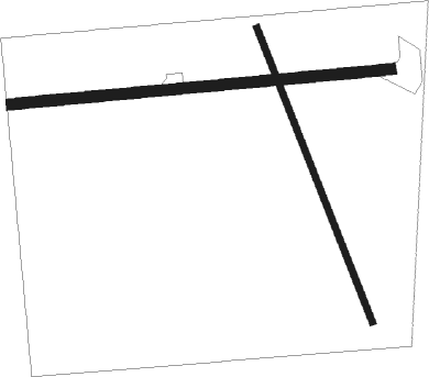
Runway info
Runway 08 / 26  | ||
| length | 885m (2904ft) | |
| bearing | 89° / 269° | |
| width | 26m (85ft) | |
| surface | grass | |
| Runway 15 / 33 | ||
| length | 732m (2402ft) | |
| bearing | 161° / 341° | |
| width | 15m (50ft) | |
| surface | grass | |
Nearby beacons
| code | identifier | dist | bearing | frequency |
|---|---|---|---|---|
| HR | SEBAS (HARLINGEN) NDB | 11.5 | 136° | 338 |
| HRL | HARLINGEN VOR/DME | 15.4 | 147° | 113.65 |
| MFE | MC ALLEN VOR/DME | 29 | 238° | 117.20 |
| MF | MISSI (MC ALLEN) NDB | 30 | 249° | 330 |
| BR | DEPOO (BROWNSVILLE) NDB | 32 | 148° | 393 |
| EOC | COYOTE (ENCINO) NDB | 33.1 | 314° | 232 |
| REX | REYNOSA VOR/DME | 35.3 | 225° | 112.40 |
| BRO | BROWNSVILLE VORTAC | 38.9 | 141° | 116.30 |
| MAM | MATAMOROS VOR/DME | 43.3 | 158° | 114.30 |
Disclaimer
The information on this website is not for real aviation. Use this data with the X-Plane flight simulator only! Data taken with kind consent from X-Plane 12 source code and data files. Content is subject to change without notice.