Vejano - Alituscia
Airport details
| Country | Italy |
| State | Lazio |
| Region | |
| Airspace | Rome Ctr |
| Municipality | Vejano |
| Elevation | 1269ft (387m) |
| Timezone | GMT +1 |
| Coordinates | 42.22424, 12.11631 |
| Magnetic var | |
| Type | land |
| Available since | X-Plane v10.30 |
| ICAO code | XLI001D |
| IATA code | n/a |
| FAA code | n/a |
Communication
Nearby Points of Interest:
chiesa di Santa Maria Assunta
-San Giovenale
-Macchia di Manziana
-Caldara di Manziana
-Tarquinia National Museum
-Santa Maria Assunta
-Ocriculum
-Santa Maria della Pietà psychiatric hospital
-Museum Venanzo Crocetti
-Villa Madama
-Castello di Alviano
-Palazzo Farrattini
-Palazzo Giustiniani
-Vatican Library
-Villa Giulia
-Museo Archeologico Nazionale di Vulci
-Palazzo Salviati
-Museo Mario Praz
-Old Rome
-Villa Doria Pamphili
-Palazzo Firenze
-Biblioteca Vallicelliana
-Biblioteca Angelica
-Palazzo Casali
-Giorgio De Chirico House
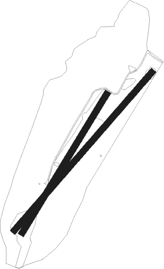
Runway info
Runway 03 / 21  | ||
| length | 692m (2270ft) | |
| bearing | 44° / 224° | |
| width | 27m (90ft) | |
| surface | grass | |
| Runway 05 / 23 | ||
| length | 895m (2936ft) | |
| bearing | 54° / 234° | |
| width | 27m (90ft) | |
| surface | grass | |
Nearby beacons
| code | identifier | dist | bearing | frequency |
|---|---|---|---|---|
| CMP | CAMPAGNANO VOR/DME | 13.2 | 111° | 111.40 |
| VIB | VITERBO NDB | 13.2 | 345° | 480 |
| TAQ | TARQUINIA VOR/DME | 17 | 269° | 111.80 |
| URB | URBE (ROME) NDB | 23.6 | 127° | 285 |
| OST | OSTIA NDB | 25.7 | 164° | 327 |
| OST | OSTIA VOR/DME | 25.8 | 164° | 114.90 |
| ROM | ROME VOR/DME | 32.8 | 132° | 110.80 |
| TPR | PRATICA DI MARE TACAN | 39.9 | 148° | 108.70 |
| LAT | LATINA VOR/DME | 54.4 | 130° | 111.20 |
| PRU | PERUGIA NDB | 55.5 | 24° | 398 |
Disclaimer
The information on this website is not for real aviation. Use this data with the X-Plane flight simulator only! Data taken with kind consent from X-Plane 12 source code and data files. Content is subject to change without notice.