Hollym
Airport details
| Country | United Kingdom |
| State | England |
| Region | |
| Airspace | London Ctr |
| Municipality | East Riding of Yorkshire |
| Elevation | 36ft (11m) |
| Timezone | GMT +0 |
| Coordinates | 53.71559, 0.04904 |
| Magnetic var | |
| Type | land |
| Available since | X-Plane v10.40 |
| ICAO code | XHOLM |
| IATA code | n/a |
| FAA code | n/a |
Communication
| Hollym SAFETYCOM | 135.475 |
Nearby Points of Interest:
Church of St Helen
-Spurn Point Low Light
-Grimsby Dock Tower
-Grimsby Ice Factory
-Thorngumbald Clough High Lighthouse
-Thorngumbald Clough Low Lighthouse
-Council House
-Paull Lighthouse
-Town Hall
-Killingholme South Low Lighthouse
-Killingholme North Low Lighthouse
-Killingholme High Lighthouse
-Blaydes House
-Tidal Surge Barrier, River Hull
-Rise Hall
-Guildhall, Kingston upon Hull
-Charterhouse, Kingston upon Hull
-St Charles Borromeo, Hull
-Brocklesby railway station
-Wassand Hall
-thornton hunt inn
-Carnegie Heritage Centre
-The Old Vicarage
-Thwaite Hall
-Tyrwhitt Hall
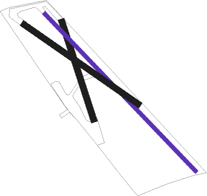
Runway info
Runway 16 / 34  | ||
| length | 250m (820ft) | |
| bearing | 158° / 338° | |
| width | 15m (49ft) | |
| surface | grass | |
| Runway 14 / 32 | ||
| length | 534m (1752ft) | |
| bearing | 126° / 306° | |
| width | 10m (33ft) | |
| surface | grass | |
| Runway 13 / 31 | ||
| length | 341m (1119ft) | |
| bearing | 116° / 296° | |
| width | 15m (48ft) | |
| surface | grass | |
Nearby beacons
| code | identifier | dist | bearing | frequency |
|---|---|---|---|---|
| OTR | OTTRINGHAM VOR/DME | 5.5 | 264° | 113.90 |
| KIM | HUMBERSIDE NDB | 16.6 | 251° | 365 |
| CGY | CONINGSBY TACAN | 38.3 | 199° | 111.10 |
| WAD | WADDINGTON TACAN | 38.9 | 226° | 117.10 |
| FNY | DONCASTER SHEFFIELD NDB | 40.1 | 257° | 338 |
| GAM | GAMSTON VOR/DME | 44.1 | 246° | 112.80 |
| CWZ | CRANWELL TACAN | 45.4 | 218° | 117.40 |
| CWL | CRANWELL NDB | 45.6 | 218° | 423 |
Disclaimer
The information on this website is not for real aviation. Use this data with the X-Plane flight simulator only! Data taken with kind consent from X-Plane 12 source code and data files. Content is subject to change without notice.