Karlstadt - Karlstadt Saupurzel
Airport details
| Country | Germany |
| State | Bavaria |
| Region | |
| Airspace | Langen Ctr |
| Municipality | Karlstadt |
| Elevation | 798ft (243m) |
| Timezone | GMT +1 |
| Coordinates | 49.97189, 9.78918 |
| Magnetic var | |
| Type | land |
| Available since | X-Plane v10.40 |
| ICAO code | XEDDF |
| IATA code | n/a |
| FAA code | n/a |
Communication
| Karlstadt Saupurzel Segelfluggelaende Saupurzel | 122.630 |
Nearby Points of Interest:
Hauptstraße 7
-Hauptstraße 9/11
-Rathaus
-Burgstall Slorburg
-Kapelle
-Maria Sondheim
-Bürgerzentrum
-Burg Arnstein
-Filialkirche
-Schloss Rodenbach
-Pfarrkirche
-Synagoge
-Pfarrhaus
-Amtsgericht
-Mönchsturm (Hammelburg)
-Pfarrhof
-Tretstein waterfall
-Burgstall Erbshausen
-Evangelische Kirche (Waizenbach)
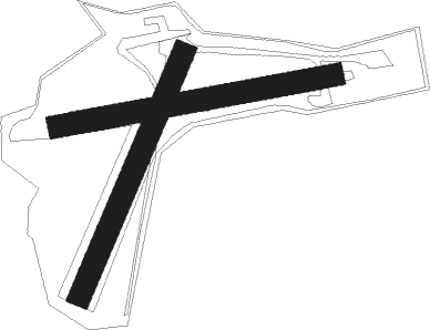
Runway info
Runway 08 / 26  | ||
| length | 436m (1430ft) | |
| bearing | 86° / 266° | |
| width | 35m (115ft) | |
| surface | grass | |
| Runway 02 / 20 | ||
| length | 410m (1345ft) | |
| bearing | 39° / 219° | |
| width | 35m (115ft) | |
| surface | grass | |
Nearby beacons
| code | identifier | dist | bearing | frequency |
|---|---|---|---|---|
| CHA | CHARLIE VOR/DME | 29.1 | 266° | 115.35 |
| GED | GEDERN VORTAC | 33.6 | 309° | 110.80 |
| NDD | DME-ILS | 35.3 | 163° | 108.70 |
| NSN | NIEDERSTETTEN NDB | 35.3 | 163° | 311 |
| ILM | ILLESHEIM NDB | 37.9 | 130° | 488 |
| FUL | FULDA VOR/DME | 38.1 | 341° | 112.10 |
| MTR | METRO VOR | 40.5 | 288° | 110 |
| SHD | HALL DME | 51.3 | 181° | 108.05 |
| ANS | ANSBACH NDB | 51.5 | 128° | 452 |
| DKB | DINKELSBUEHL VORTAC | 52.7 | 152° | 117.80 |
Disclaimer
The information on this website is not for real aviation. Use this data with the X-Plane flight simulator only! Data taken with kind consent from X-Plane 12 source code and data files. Content is subject to change without notice.