Grevenbroich - Gustorfer Hoehe
Airport details
| Country | Germany |
| State | North Rhine-Westphalia |
| Region | |
| Airspace | Langen Ctr |
| Municipality | Grevenbroich |
| Elevation | 289ft (88m) |
| Timezone | GMT +1 |
| Coordinates | 51.07648, 6.54032 |
| Magnetic var | |
| Type | land |
| Available since | X-Plane v10.40 |
| ICAO code | XED002Q |
| IATA code | n/a |
| FAA code | n/a |
Communication
| Gustorfer Hoehe Gustorfer Hoehe | 135.090 |
Nearby Points of Interest:
Kloster Grevenbroich
-Haus Neuenhoven
-Wegekreuz Heyers
-St. Georg
-Church of St. Martin, Borschemich
-Windmühle
-St. Maria Schmerzhafte Mutter
-St. Lambertus
-An der Bleiche 1
-Wegekreuz Wanlo
-Carl-Diem-Straße 6
-Schloss-Dyck-Straße 128
-Schloss-Dyck-Straße 129
-Schule Odenkirchen
-Schmidt-Bleibtreu-Straße 4
-Schmidt-Bleibtreu-Straße 8
-Schmidt-Bleibtreu-Straße 18
-Schmidt-Bleibtreu-Straße 2
-Schmidt-Bleibtreu-Straße 38
-Schmidt-Bleibtreu-Straße 32
-Wilhelm-Niessen-Straße 7
-Wilhelm-Niessen-Straße 5
-Schmidt-Bleibtreu-Straße 28
-Schmidt-Bleibtreu-Straße 40
-Schmidt-Bleibtreu-Straße 48
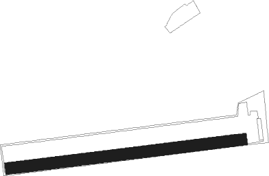
Runway info
| Runway 08 / 26 | ||
| length | 984m (3228ft) | |
| bearing | 88° / 268° | |
| width | 50m (164ft) | |
| surface | grass | |
Nearby beacons
| code | identifier | dist | bearing | frequency |
|---|---|---|---|---|
| MHD | DME | 9.6 | 343° | 112.50 |
| MHV | MOENCHENGLADBACH VOR | 9.8 | 343° | 109.80 |
| DY | DUESSELDORF NDB | 10.4 | 36° | 284 |
| DUS | DUESSELDORF VOR/DME | 14.7 | 46° | 115.15 |
| WNN | DME | 15.2 | 152° | 109.85 |
| NVO | NOERVENICH VORTAC | 15.6 | 159° | 116.20 |
| LMA | LIMA NDB | 18.5 | 334° | 311 |
| GIX | GEILENKIRCHEN TACAN | 19.9 | 257° | 108.10 |
| LI | DUESSELDORF NDB | 20.9 | 52° | 417 |
| LJ | COLOGNE-BONN NDB | 21.6 | 106° | 365 |
| MAS | MAASTRICHT VOR/DME | 22.7 | 260° | 108.60 |
| NW | MAASTRICHT NDB | 25.2 | 265° | 373 |
| KBO | COLOGNE-BONN VOR/DME | 26.2 | 110° | 112.15 |
| WYP | WIPPER VOR | 27.9 | 92° | 109.60 |
| BAM | BARMEN VOR/DME | 28.3 | 68° | 114 |
| LW | COLOGNE-BONN NDB | 28.9 | 104° | 300 |
| LV | COLOGNE-BONN NDB | 31.1 | 111° | 327 |
| LAA | NIEDERRHEIN NDB | 34.4 | 325° | 352 |
| NID | DME | 34.8 | 323° | 115.50 |
| BOT | BOTTROP NDB | 35.5 | 43° | 406 |
| LNO | OLNO VOR/DME | 43.1 | 239° | 112.80 |
| SLV | SPA NDB | 43.1 | 226° | 386 |
| ONL | LIEGE NDB | 43.7 | 249° | 290 |
| VKL | VOLKEL TACAN | 46.7 | 305° | 108.30 |
| SPI | SPRIMONT VOR/DME | 48.4 | 238° | 113.10 |
| BUE | BUECHEL TACAN | 57.5 | 149° | 117.10 |
| DLN | DEELEN TACAN | 63.9 | 326° | 112.20 |
Disclaimer
The information on this website is not for real aviation. Use this data with the X-Plane flight simulator only! Data taken with kind consent from X-Plane 12 source code and data files. Content is subject to change without notice.