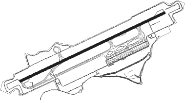
Kannur Intl
Airport details
| Country | India |
| State | Kerala |
| Region | |
| Airspace | Chennai Ctr |
| Municipality | Thalassery |
| Elevation | 344ft (105m) |
| Timezone | GMT +5.5 |
| Coordinates | 11.91720, 75.54746 |
| Magnetic var | |
| Type | land |
| Available since | X-Plane v10.40 |
| ICAO code | VOKN |
| IATA code | CNN |
| FAA code | n/a |
Communication
| Kannur Intl ATIS | 128.800 |
| Kannur Intl Tower | 121.975 |
| Kannur Intl Tower | 118.050 |
| Kannur Intl Approach | 121.175 |
| Kannur Intl Approach | 121.975 |
Approach frequencies
| ILS-cat-I | RW25 | 108.9 | 18.00mi |
| 3° GS | RW25 | 108.9 | 18.00mi |
Nearby Points of Interest:
Aralam Wildlife Sanctuary
Nearby beacons
| code | identifier | dist | bearing | frequency |
|---|---|---|---|---|
| KNR | KANNUR VOR/DME | 0.8 | 264° | 112.60 |
| CLC | CALICUT VOR/DME | 52.8 | 152° | 116.50 |
Instrument approach procedures
| runway | airway (heading) | route (dist, bearing) |
|---|---|---|
| RW07-Y | KN411 (42°) | KN411 3000ft KN412 (7mi, 339°) 3000ft |
| RW07-Y | KN413 (97°) | KN413 3000ft KN412 (7mi, 159°) 3000ft |
| RNAV | KN412 3000ft KN414 (6mi, 69°) 2400ft VOKN (8mi, 70°) 394ft KN415 (11mi, 69°) KN416 (7mi, 339°) KN413 (24mi, 249°) KN412 (7mi, 159°) 3000ft KN412 (turn) 3000ft |
Disclaimer
The information on this website is not for real aviation. Use this data with the X-Plane flight simulator only! Data taken with kind consent from X-Plane 12 source code and data files. Content is subject to change without notice.