Atlanta - Graham Usfs
Airport details
| Country | United States of America |
| State | Idaho |
| Region | |
| Airspace | Salt Lake City Ctr |
| Municipality | Elmore County |
| Elevation | 5726ft (1745m) |
| Timezone | GMT -7 |
| Coordinates | 43.95910, -115.27059 |
| Magnetic var | |
| Type | land |
| Available since | X-Plane v10.40 |
| ICAO code | U45 |
| IATA code | n/a |
| FAA code | U45 |
Communication
Nearby Points of Interest:
Atlanta Ranger Station Historic District
-South Boise Historic Mining District
-Central Idaho Dark Sky Reserve
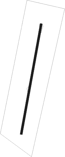
Runway info
| Runway 18 / 36 | ||
| length | 916m (3005ft) | |
| bearing | 200° / 20° | |
| width | 19m (62ft) | |
| surface | dirt | |
Nearby beacons
| code | identifier | dist | bearing | frequency |
|---|---|---|---|---|
| BOI | BOISE VORTAC | 46.8 | 246° | 113.30 |
| MUO | MOUNTAIN HOME TACAN | 61.1 | 213° | 114 |
| LIA | LIBERATOR VOR | 62.6 | 207° | 114.90 |
| DNJ | DONNELLY (MC CALL) VOR/DME | 62.9 | 311° | 116.20 |
Disclaimer
The information on this website is not for real aviation. Use this data with the X-Plane flight simulator only! Data taken with kind consent from X-Plane 12 source code and data files. Content is subject to change without notice.