Segundo Corral - Segundo Corral Alto
Airport details
| Country | Chile |
| State | Los Lagos Region |
| Region | SC |
| Airspace | Puerto Montt Ctr |
| Municipality | Cochamó |
| Elevation | 1200ft (366m) |
| Timezone | GMT -3 |
| Coordinates | -42.08333, -71.86389 |
| Magnetic var | |
| Type | land |
| Available since | X-Plane v10.40 |
| ICAO code | SCSR |
| IATA code | n/a |
| FAA code | n/a |
Communication
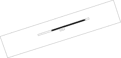
Runway info
| Runway 07 / 25 | ||
| length | 739m (2425ft) | |
| bearing | 80° / 260° | |
| width | 20m (66ft) | |
| surface | gravel | |
Nearby beacons
| code | identifier | dist | bearing | frequency |
|---|---|---|---|---|
| ESQ | ESQUEL VOR/DME | 58.9 | 136° | 117.80 |
| L | BRIG. GRAL. ANTONIO PARODI NDB | 58.9 | 137° | 260 |
| TEN | CHAITEN VOR/DME | 60.5 | 234° | 112.30 |
| OB | SAN CARLOS DE BARILOCHE NDB | 64.1 | 33° | 330 |
| B | BRAVO (S C DE BARILOCHE) NDB | 64.2 | 36° | 305 |
| BAR | SAN CARLOS DE BARILOCHE VOR/DME | 64.2 | 36° | 117.40 |
Disclaimer
The information on this website is not for real aviation. Use this data with the X-Plane flight simulator only! Data taken with kind consent from X-Plane 12 source code and data files. Content is subject to change without notice.