Manapouri-te Anau
Airport details
| Country | New Zealand |
| State | Southland |
| Region | NZ |
| Municipality | Fiordland Community |
| Elevation | 687ft (209m) |
| Timezone | GMT +12 |
| Coordinates | -45.53411, 167.64195 |
| Magnetic var | |
| Type | land |
| Available since | X-Plane v10.40 |
| ICAO code | NZMO |
| IATA code | TEU |
| FAA code | n/a |
Communication
| Manapouri-Te Anau QUEENSTOWN FSS | 128.000 |
| Manapouri-Te Anau MANAPOURI Ground Control | 128.750 |
| Manapouri-Te Anau MANAPOURI Tower | 118.500 |
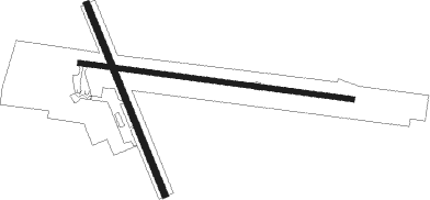
Runway info
Runway 08 / 26  | ||
| length | 1586m (5203ft) | |
| bearing | 98° / 278° | |
| width | 30m (98ft) | |
| surface | asphalt | |
| Runway 18 / 36 | ||
| length | 1183m (3881ft) | |
| bearing | 155° / 335° | |
| width | 35m (115ft) | |
| surface | grass | |
Nearby beacons
| code | identifier | dist | bearing | frequency |
|---|---|---|---|---|
| NV | INVERCARGILL VOR/DME | 59.7 | 142° | 116.80 |
Departure and arrival routes
| Transition altitude | 13000ft |
| Transition level | 15000ft |
| SID end points | distance | outbound heading | |
|---|---|---|---|
| RW26 | |||
| GULAN1 | 42mi | 86° | |
| STAR starting points | distance | inbound heading | |
|---|---|---|---|
| RW26 | |||
| ANGU1G | 30.2 | 244° | |
| PEXE1G | 29.9 | 318° | |
Instrument approach procedures
| runway | airway (heading) | route (dist, bearing) |
|---|---|---|
| RW26 | ALDEV (257°) | ALDEV GULAN (7mi, 205°) 4400ft |
| RW26 | ENSOV (283°) | ENSOV GULAN (7mi, 324°) 4800ft |
| RW26 | GULAN (271°) | GULAN 7000ft |
| RNAV | GULAN 4400ft FF26 (10mi, 266°) 2810ft MA26 (5mi, 278°) 1211ft MO633 (8mi, 26°) MO714 (8mi, 86°) MO714 (turn) 5000ft GULAN (9mi, 147°) 7000ft GULAN (turn) 7000ft |
Disclaimer
The information on this website is not for real aviation. Use this data with the X-Plane flight simulator only! Data taken with kind consent from X-Plane 12 source code and data files. Content is subject to change without notice.