Nové Město Nad Metují Moravě - Nove Mesto
Airport details
| Country | Czechia |
| State | Northeast |
| Region | LK |
| Airspace | Prague Ctr |
| Municipality | Nové Město nad Metují |
| Elevation | 1000ft (305m) |
| Timezone | GMT +1 |
| Coordinates | 50.36417, 16.11361 |
| Magnetic var | |
| Type | land |
| Available since | X-Plane v10.40 |
| ICAO code | LKNM |
| IATA code | n/a |
| FAA code | n/a |
Communication
| Nove Mesto INFO | 123.400 |
Nearby Points of Interest:
Brána do vsi
-kostel svatého Jakuba Staršího (Černčice)
-Statue of Saint John of Nepomuk in Nové Město nad Metují
-Maria column in Nové Město nad Metují
-City walls of Nové Město nad Metují
-Masné krámy
-Nové Město nad Metují
-Socha svatého Jana Nepomuckého
-Sculpture of the Crucifixion (Velká Jesenice)
-certovka peklo
-Socha svatého Václava
-Socha Panny Marie Ochranitelky
-Sloup se sochou Panny Marie
-Villa Čerych
-Church of Saint Nicholas
-Chapel of Saint Francis of Assisi (Velká Jesenice)
-Bartoňova vila
-New townhall in Náchod
-Old town hall in Náchod
-Library in Náchod
-Mlýn U Ondřejců
-Brewery Dobruška
-Kostel svatého Jana Křtitele
-Synagogue in Dobruška
-Chapel of Saint Hubertus
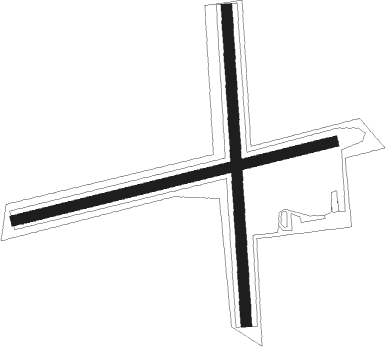
Runway info
Runway 18 / 36  | ||
| length | 891m (2923ft) | |
| bearing | 181° / 1° | |
| width | 30m (98ft) | |
| surface | grass | |
| Runway 08 / 26 | ||
| length | 930m (3051ft) | |
| bearing | 84° / 264° | |
| width | 28m (92ft) | |
| surface | grass | |
Nearby beacons
| code | identifier | dist | bearing | frequency |
|---|---|---|---|---|
| PK | PARDUBICE NDB | 24.1 | 220° | 432 |
| P | PARDUBICE NDB | 24.9 | 224° | 888 |
| C | CASLAV NDB | 37.9 | 238° | 715 |
| CF | CASLAV NDB | 38 | 236° | 345 |
| F | CASLAV NDB | 38 | 242° | 715 |
| WCL | WROCLAW VOR/DME | 53.3 | 48° | 111.65 |
Disclaimer
The information on this website is not for real aviation. Use this data with the X-Plane flight simulator only! Data taken with kind consent from X-Plane 12 source code and data files. Content is subject to change without notice.