Guidonia
Airport details
| Country | Italy |
| State | Lazio |
| Region | LI |
| Airspace | Rome Ctr |
| Municipality | Guidonia Montecelio |
| Elevation | 289ft (88m) |
| Timezone | GMT +1 |
| Coordinates | 41.99483, 12.73728 |
| Magnetic var | |
| Type | land |
| Available since | X-Plane v10.40 |
| ICAO code | LIRG |
| IATA code | n/a |
| FAA code | n/a |
Communication
| GUIDONIA Tower | 122.200 |
| GUIDONIA Tower | 122.100 |
Nearby Points of Interest:
ponte Lupo Acqua Rossa
-Palazzo Giustiniani
-Modern and Contemporary Art Museum
-Biblioteca universitaria Alessandrina
-Biblioteca medica statale Rome
-Biblioteca Nazionale Centrale di Roma
-Aqua Marcia
-Anio Novus
-Palazzo Leoni, Bologna
-Aqua Claudia
-Museum of the Baths of Diocletian
-Palazzo Massimo alle Terme
-parco archeologico Appia antica - tombe della via Latina
-Antiquarium Lucrezia Romana
-Palazzo Brancaccio
-Villa Giustiniani Massimo
-Palazzo Barberini Mithraeum
-Palazzo Cimarra
-Galleria d'arte moderna di Roma Capitale
-Palazzo del Tritone
-Villa Giulia
-Baths of Titus
-Santa Maria delle Lauretane
-Palazzo Koch
-Giorgio De Chirico House
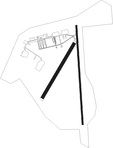
Runway info
Runway 18 / 36  | ||
| length | 1728m (5669ft) | |
| bearing | 181° / 1° | |
| width | 30m (98ft) | |
| surface | asphalt | |
| displ threshold | 140m (459ft) / 152m (499ft) | |
| Runway 03 / 21 | ||
| length | 1075m (3527ft) | |
| bearing | 43° / 223° | |
| width | 59m (194ft) | |
| surface | grass | |
Nearby beacons
| code | identifier | dist | bearing | frequency |
|---|---|---|---|---|
| URB | URBE (ROME) NDB | 11.4 | 259° | 285 |
| ROM | ROME VOR/DME | 13.2 | 218° | 110.80 |
| CMP | CAMPAGNANO VOR/DME | 17.6 | 290° | 111.40 |
| TPR | PRATICA DI MARE TACAN | 24.9 | 213° | 108.70 |
| OST | OSTIA NDB | 25.1 | 249° | 327 |
| LAT | LATINA VOR/DME | 28.4 | 158° | 111.20 |
| FRS | FROSINONE VOR/DME | 32.6 | 122° | 115.60 |
| VIB | VITERBO NDB | 40.3 | 303° | 480 |
Disclaimer
The information on this website is not for real aviation. Use this data with the X-Plane flight simulator only! Data taken with kind consent from X-Plane 12 source code and data files. Content is subject to change without notice.