Kecskéd
Airport details
| Country | Hungary |
| State | Komárom-Esztergom |
| Region | LH |
| Airspace | Budapest Ctr |
| Municipality | Kecskéd |
| Elevation | 568ft (173m) |
| Timezone | GMT +1 |
| Coordinates | 47.51714, 18.32502 |
| Magnetic var | |
| Type | land |
| Available since | X-Plane v10.40 |
| ICAO code | LHKD |
| IATA code | n/a |
| FAA code | n/a |
Communication
| Kecskéd Kecskéd RADIO | 120.600 |
Nearby Points of Interest:
Vértesi Tájvédelmi Körzet
-Velencei madárrezervátum
-Béla király 20, Frivaldszky Villa
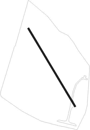
Runway info
| Runway 15 / 33 | ||
| length | 1238m (4062ft) | |
| bearing | 144° / 324° | |
| width | 25m (82ft) | |
| surface | grass | |
Nearby beacons
| code | identifier | dist | bearing | frequency |
|---|---|---|---|---|
| GYR | GYOR VOR/DME | 25.7 | 283° | 115.10 |
| PTB | PUSZTASZABOLCS VOR/DME | 27.7 | 131° | 117.10 |
| P | PAPA NDB | 34.6 | 258° | 493 |
| PC | PAPA NDB | 34.6 | 256° | 318 |
| C | PAPA NDB | 34.8 | 261° | 493 |
| PCT | PAPA VORTAC | 34.8 | 261° | 114.75 |
| CP | PAPA NDB | 35 | 263° | 318 |
| BUD | BUDAPEST VOR/DME | 37.7 | 94° | 117.30 |
| SVR | SAGVAR VOR/DME | 42.2 | 197° | 117.70 |
| NIT | NITRA VOR/DME | 47.7 | 340° | 116.50 |
| JAN | JANOVCE VOR/DME | 50.6 | 310° | 110.80 |
| SLC | SLIAC VOR/DME | 64.5 | 40° | 114 |
Disclaimer
The information on this website is not for real aviation. Use this data with the X-Plane flight simulator only! Data taken with kind consent from X-Plane 12 source code and data files. Content is subject to change without notice.