Plivot - Epernay Plivot
Airport details
| Country | France |
| State | Grand Est |
| Region | LF |
| Airspace | Paris Ctr |
| Municipality | Plivot |
| Elevation | 289ft (88m) |
| Timezone | GMT +1 |
| Coordinates | 49.00444, 4.08528 |
| Magnetic var | |
| Type | land |
| Available since | X-Plane v10.40 |
| ICAO code | LFSW |
| IATA code | n/a |
| FAA code | n/a |
Communication
| Epernay Plivot CTAF | 123.500 |
Nearby Points of Interest:
Grotte de Saran IV
-De Castellane
-Pont d'Épernay
-Hôpital Auban-Moët
-Town hall of Épernay
-Synagogue of Épernay
-Ancienne église Saint-Martin (Épernay)
-Temple de l'église réformée de France d'Épernay
-Maison Les Aulnois
-Fort Chabrol
-Tumuli de Bussy-le-Château
-Ancienne porte Marne
-Hôtel-Dieu-Saint-Étienne
-Pont des Mariniers
-Pont des Faignants
-Ancien couvent des Cordeliers de Châlons-en-Champagne
-Temple
-Synagogue of Châlons-en-Champagne
-Maison Royer et Granthille
-Maisons canoniales
-musée des Beaux-Arts et d'Archéologie de Châlons-en-Champagne
-Marché couvert
-couvent Sainte-Marie de Châlons-en-Champagne
-7-11 avenue Maréchal Leclerc
-Couvent de Vinetz
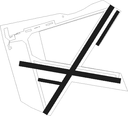
Runway info
Runway 04 / 22  | ||
| length | 1201m (3940ft) | |
| bearing | 48° / 228° | |
| width | 50m (164ft) | |
| surface | grass | |
| Runway 04R / 22L | ||
| length | 366m (1201ft) | |
| bearing | 48° / 228° | |
| width | 30m (98ft) | |
| surface | grass | |
| Runway 10 / 28 | ||
| length | 961m (3153ft) | |
| bearing | 100° / 280° | |
| width | 50m (164ft) | |
| surface | grass | |
| displ threshold | 60m (197ft) / 0m (0ft) | |
| Runway 10R / 28L | ||
| length | 200m (656ft) | |
| bearing | 100° / 280° | |
| width | 30m (98ft) | |
| surface | grass | |
Nearby beacons
| code | identifier | dist | bearing | frequency |
|---|---|---|---|---|
| VAT | CHALONS NDB | 12.7 | 199° | 367 |
| CAV | CHALONS VOR/DME | 13.6 | 165° | 111.65 |
| CVT | CHALONS NDB | 17.3 | 136° | 347 |
| REM | REIMS VOR | 18.5 | 353° | 112.30 |
| CTL | CHATILLON SUR MARNE VOR/DME | 21.5 | 285° | 117.60 |
| TY | TROYES NDB | 36.4 | 188° | 320 |
| SDI | SAINT DIZIER ROBINSON TACAN | 38.6 | 115° | 114 |
| TRO | TROYES BARBEREY VOR | 45.4 | 189° | 116 |
| BRY | BRAY SUR SEINE VOR/DME | 47.6 | 233° | 114.10 |
Disclaimer
The information on this website is not for real aviation. Use this data with the X-Plane flight simulator only! Data taken with kind consent from X-Plane 12 source code and data files. Content is subject to change without notice.