Cahors - Figeac Livernon
Airport details
| Country | France |
| State | Occitania |
| Region | LF |
| Airspace | Bordeaux Ctr |
| Municipality | Durbans |
| Elevation | 1083ft (330m) |
| Timezone | GMT +1 |
| Coordinates | 44.67250, 1.78806 |
| Magnetic var | |
| Type | land |
| Available since | X-Plane v10.40 |
| ICAO code | LFCF |
| IATA code | n/a |
| FAA code | n/a |
Communication
| Figeac Livernon Livernon A/A | 123.500 |
Nearby Points of Interest:
Pigeonnier du château d'Assier
-Hôpital des religieuses de Beaulieu
-Dolmen de la Baune
-Maison Réveillac
-Dolmen des Plassous
-Pigeonnier-porche de Lavergne
-Basilique Saint-Sauveur de Rocamadour
-Maison du Griffon
-Maison de l'Hébrardie
-Château de Larnagol
-chapelle de la Madeleine de Cajarc
-Pont de Maday
-Croix en pierre
-Château de Saint-Julien d'Empare
-aqueduc de Vers
-Château de la Treyne
-Pont Roman
-maison aux pigeonniers
-Borie de Savanac
-fontaine de l'Oulié
-Maison Arcambal
-église Saint-Antoine d'Arcambal
-Hôtel Fabri
-Hôtel de ville de Martel
-Maison Cavaignac
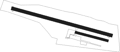
Runway info
Runway 11 / 29  | ||
| length | 883m (2897ft) | |
| bearing | 104° / 284° | |
| width | 30m (98ft) | |
| surface | asphalt | |
| displ threshold | 0m (0ft) / 160m (525ft) | |
| Runway 11R / 29L | ||
| length | 280m (919ft) | |
| bearing | 104° / 284° | |
| width | 20m (66ft) | |
| surface | grass | |
Nearby beacons
| code | identifier | dist | bearing | frequency |
|---|---|---|---|---|
| FC | FIGEAC LIVERNON NDB | 0.1 | 215° | 395 |
| BSC | SOUILLAC (BRIVE) NDB | 20.6 | 333° | 351 |
| CL | CAHORS NDB | 23.4 | 232° | 348 |
| AR | AURILLAC NDB | 29.9 | 64° | 343 |
| RZ | RODEZ NDB | 31.3 | 110° | 387 |
| ROM | RODEZ NDB | 40.6 | 113° | 302 |
| GAI | GAILLAC VOR | 43.1 | 177° | 115.80 |
| TLB | TOULOUSE NDB | 46 | 206° | 368 |
| AB | ALBI NDB | 47.1 | 160° | 323 |
| PX | PERIGUEUX NDB | 47.5 | 299° | 389 |
| AGN | AGEN VOR/DME | 61.3 | 229° | 114.80 |
| TOU | TOULOUSE BLAGNAC VOR/DME | 63 | 206° | 117.70 |
Disclaimer
The information on this website is not for real aviation. Use this data with the X-Plane flight simulator only! Data taken with kind consent from X-Plane 12 source code and data files. Content is subject to change without notice.