Vandalia - Vandalia Muni
Airport details
| Country | United States of America |
| State | Illinois |
| Region | K5 |
| Airspace | Kansas City Ctr |
| Municipality | Fayette County |
| Elevation | 537ft (164m) |
| Timezone | GMT -6 |
| Coordinates | 38.99131, -89.16622 |
| Magnetic var | |
| Type | land |
| Available since | X-Plane v10.40 |
| ICAO code | KVLA |
| IATA code | VLA |
| FAA code | VLA |
Communication
| Vandalia Muni CTAF/UNICOM | 122.800 |
Nearby Points of Interest:
Little Brick House
-First Presbyterian Church
-Floyd and Glenora Dycus House
-Greenville Public Library
-Hayward-Hill House
-George Blackman House
-Freeman-Brewer-Sawyer House
-Montgomery County Courthouse
-Dr. Charles M. Wright House
-Calendar Rohrbough House
-Louis Jehle House
-Badollet House
-Charles and Naomi Bachmann House
-William Jennings Bryan Boyhood Home
-General Dean Suspension Bridge
-Samuel Moody Grubbs House
-Brown Shoe Company Factory
-Litchfield Elks Lodge No. 654
-Litchfield Public Library
-Manske-Niemann Farm
-Centralia Commercial Historic District
-Centralia Elks Lodge
-Sentinel Building
-Clarksburg Schoolhouse
-U.S. Route 66
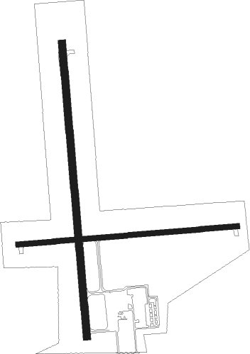
Runway info
Runway 18 / 36  | ||
| length | 1221m (4006ft) | |
| bearing | 180° / 360° | |
| width | 30m (100ft) | |
| surface | asphalt | |
| displ threshold | 0m (0ft) / 76m (249ft) | |
| Runway 9 / 27 | ||
| length | 913m (2995ft) | |
| bearing | 90° / 270° | |
| width | 23m (75ft) | |
| surface | asphalt | |
Nearby beacons
| code | identifier | dist | bearing | frequency |
|---|---|---|---|---|
| VLA | VANDALIA VOR/DME | 6.1 | 2° | 114.30 |
| GRE | GREENVILLE NDB | 13.4 | 233° | 233 |
| SYZ | SHELBYVILLE NDB | 29.1 | 38° | 365 |
| BIB | BIBLE GROVE VORTAC | 32.2 | 96° | 109 |
| ENL | CENTRALIA VORTAC | 34.3 | 179° | 115 |
| TOY | TROY VORTAC | 38.3 | 251° | 116 |
| JD | GOOEY (BELLEVILLE) NDB | 40.8 | 228° | 385 |
| VNN | VERNON DME | 41.3 | 150° | 113.80 |
| SKE | SCOTT (BELLEVILLE) TACAN | 41.8 | 237° | 112.20 |
| CVM | CIVIC MEMORIAL (ALTON) NDB | 41.9 | 264° | 263 |
| AXC | ADDERS VORTAC | 47 | 23° | 117.20 |
| DE | ELWIN (DECATUR) NDB | 48.9 | 15° | 275 |
| OLY | OLNEY NDB | 49.2 | 105° | 272 |
| MTO | DME | 50.2 | 61° | 109.40 |
| CP | ACORE (CAHOKIA/ST LOUIS) NDB | 50.5 | 242° | 350 |
| FWC | WAYNE CO (FAIRFIELD) NDB | 51 | 129° | 257 |
| CJ | CALDE (SPRINGFIELD) NDB | 52.1 | 332° | 240 |
| SP | HUSKK (SPRINGFIELD) NDB | 54.4 | 323° | 382 |
| SPI | SPINNER (SPRINGFIELD) VORTAC | 56.2 | 329° | 112.70 |
| LQ | LICOL (SPRINGFIELD) NDB | 58.8 | 335° | 375 |
| CM | VEALS (CHAMPAIGN/URBANA) NDB | 74.2 | 45° | 407 |
Instrument approach procedures
| runway | airway (heading) | route (dist, bearing) |
|---|---|---|
| RW18 | AQUAS (207°) | AQUAS LITIC (20mi, 222°) 2400ft |
| RW18 | CLEEK (152°) | CLEEK LITIC (22mi, 139°) 2400ft |
| RW18 | VLA (182°) | VLA LITIC (6mi, 356°) 2400ft LITIC (turn) 2400ft |
| RNAV | LITIC 2400ft WIRPA (6mi, 180°) 2300ft KVLA (6mi, 179°) 570ft (5366mi, 114°) 937ft SEYRO (5366mi, 294°) 2400ft SEYRO (turn) | |
| RW36 | ENL (359°) | ENL SEYRO (23mi, 359°) 2400ft |
| RW36 | VLA (182°) | VLA SEYRO (18mi, 181°) 2400ft SEYRO (turn) 2400ft |
| RNAV | SEYRO 2400ft RACOV (6mi, 360°) 2300ft KVLA (6mi, 0°) 573ft (5366mi, 114°) 937ft LITIC (5366mi, 294°) 2400ft LITIC (turn) |
Disclaimer
The information on this website is not for real aviation. Use this data with the X-Plane flight simulator only! Data taken with kind consent from X-Plane 12 source code and data files. Content is subject to change without notice.