Seguin - Randolph Afb Aux
Airport details
| Country | United States of America |
| State | Texas |
| Region | K4 |
| Airspace | Houston Oceanic Ctr |
| Municipality | Guadalupe County |
| Elevation | 523ft (159m) |
| Timezone | GMT -6 |
| Coordinates | 29.56579, -97.90833 |
| Magnetic var | |
| Type | land |
| Available since | X-Plane v10.40 |
| ICAO code | KSEQ |
| IATA code | n/a |
| FAA code | SEQ |
Communication
| Randolph AFB AUX CTAF | 122.975 |
Nearby Points of Interest:
Lindheimer House
-Carl W. A. Groos House
-Comal County Courthouse
-Comal Power Plant
-Gruene Family Home
-Gruene Historic District
-State Highway 3-A Bridge at Cibolo Creek
-Farmers Union Gin Company
-Old Main
-Randolph Field Historic District
-Administration Building
-M. A. Withers House
-Caldwell County Courthouse Historic District
-Gonzales County Courthouse
-Katherine Anne Porter House
-San Antonio Military Medical Center
-Winters-Wimberley House
-Fort Sam Houston
-Monastery of Our Lady of Charity
-Fence at Alamo Cement Company
-Hangar 9, Brooks Air Force Base
-Johann and Anna Heidgen House
-Alamo Plaza Historic District
-Hipolito F. Garcia Federal Building and United States Courthouse
-Otto Bombach House
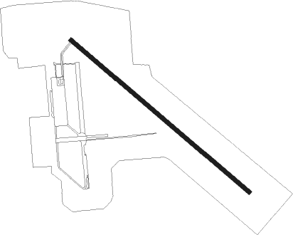
Runway info
| Runway 13 / 31 | ||
| length | 2528m (8294ft) | |
| bearing | 131° / 311° | |
| width | 46m (150ft) | |
| surface | asphalt | |
| blast zone | 255m (837ft) / 255m (837ft) | |
Nearby beacons
| code | identifier | dist | bearing | frequency |
|---|---|---|---|---|
| DHK | RANDOLPH TACAN | 18.8 | 265° | 109.90 |
| RND | RANDOLPH VORTAC | 19.8 | 263° | 112.30 |
| RU | GARYS (AUSTIN) NDB | 23.6 | 354° | 272 |
| SAT | SAN ANTONIO VORTAC | 29.2 | 278° | 116.80 |
| SSF | STINSON (SAN ANTONIO) VOR | 33.5 | 240° | 108.40 |
| AN | ALAMO (SAN ANTONIO) NDB | 34.6 | 274° | 368 |
| KSY | KELLY (SAN ANTONIO) TACAN | 36.6 | 255° | 112 |
| CWK | CENTEX VORTAC | 52.6 | 25° | 112.80 |
| STV | STONEWALL VORTAC | 56.6 | 309° | 113.80 |
| VCT | VICTORIA VOR/DME | 63 | 126° | 109 |
Disclaimer
The information on this website is not for real aviation. Use this data with the X-Plane flight simulator only! Data taken with kind consent from X-Plane 12 source code and data files. Content is subject to change without notice.