Old Town - Dewitt Fld
Airport details
| Country | United States of America |
| State | Maine |
| Region | K6 |
| Airspace | Boston Ctr |
| Municipality | Old Town |
| Elevation | 125ft (38m) |
| Timezone | GMT -5 |
| Coordinates | 44.95250, -68.67431 |
| Magnetic var | |
| Type | land |
| Available since | X-Plane v10.40 |
| ICAO code | KOLD |
| IATA code | OLD |
| FAA code | OLD |
Communication
| Dewitt Fld CTAF/UNICOM | 122.800 |
| Dewitt Fld BANGOR Approach/Departure | 124.500 |
Nearby Points of Interest:
St. Anne's Church and Mission Site
-Old Town Main Post Office
-Edith Marion Patch House
-Old Fire Engine House
-Nathaniel Treat House
-Orono Bog
-Dorothea Dix Psychiatric Center
-Bangor Fire Engine House No. 6
-Jones P. Veazie House
-Charles G. Bryant Double House
-Sargent-Roberts House
-Jonas Cutting–Edward Kent House
-Morse & Co. Office Building
-Charles W. Jenkins House
-Bangor Public Library
-Wheelwright Block
-Wardwell-Trickey Double House
-Adams-Pickering Block
-Bangor Theological Seminary
-Gen. John Williams House
-Zebulon Smith House
-East Eddington Public Hall
-Daniel Sargent House
-District No. 2 School
-Hampden Academy
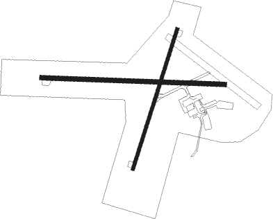
Runway info
Runway 12 / 30  | ||
| length | 1216m (3990ft) | |
| bearing | 95° / 275° | |
| width | 30m (100ft) | |
| surface | asphalt | |
| Runway 4 / 22 | ||
| length | 975m (3199ft) | |
| bearing | 30° / 210° | |
| width | 23m (75ft) | |
| surface | asphalt | |
Nearby beacons
| code | identifier | dist | bearing | frequency |
|---|---|---|---|---|
| BGR | BANGOR VORTAC | 10.7 | 241° | 114.80 |
| BUP | BURNHAM (PITTSFIELD) NDB | 32.9 | 250° | 348 |
| MLT | MILLINOCKET VOR/DME | 38.6 | 14° | 117.90 |
| LNT | MILNOT (MILLINOCKET) NDB | 42.1 | 10° | 344 |
| PNN | DME | 46.9 | 69° | 114.30 |
| SUH | SPRUCEHEAD (OWLS HEAD) NDB | 57.2 | 206° | 356 |
Instrument approach procedures
| runway | airway (heading) | route (dist, bearing) |
|---|---|---|
| RW12 | VOWPE (113°) | VOWPE 3100ft ZIMFA (5mi, 189°) 3000ft |
| RW12 | YISUY (77°) | YISUY 3000ft ZIMFA (5mi, 9°) 3000ft |
| RW12 | ZIMFA (95°) | ZIMFA 3000ft |
| RNAV | ZIMFA 3000ft UNAVY (6mi, 95°) 1700ft JUKSA (3mi, 95°) 760ft KOLD (2mi, 95°) 175ft TIGSE (11mi, 95°) 3000ft TIGSE (turn) | |
| RW22 | IVAFO (210°) | IVAFO 3000ft |
| RW22 | UNUYE (238°) | UNUYE 3000ft IVAFO (5mi, 286°) 3000ft |
| RW22 | WIRUB (174°) | WIRUB 3800ft IVAFO (5mi, 106°) 3000ft |
| RNAV | IVAFO 3000ft HUDRI (6mi, 210°) 1400ft JUBUM (2mi, 210°) 700ft KOLD (2mi, 212°) 174ft (4509mi, 123°) 530ft IVAFO (4508mi, 303°) 3000ft IVAFO (turn) | |
| RW30 | KOXWA (293°) | KOXWA 3000ft TIGSE (5mi, 9°) 3000ft OMYOX (4mi, 275°) 1900ft |
| RW30 | OBEVE (257°) | OBEVE 3100ft TIGSE (5mi, 189°) 3000ft OMYOX (4mi, 275°) 1900ft |
| RW30 | TIGSE (275°) | TIGSE 3000ft OMYOX (4mi, 275°) 1900ft |
| RNAV | OMYOX 1900ft SUMAW (2mi, 275°) 1700ft HOSOS (3mi, 275°) 780ft KOLD (2mi, 274°) 159ft ZIMFA (11mi, 275°) 3000ft ZIMFA (turn) |
Disclaimer
The information on this website is not for real aviation. Use this data with the X-Plane flight simulator only! Data taken with kind consent from X-Plane 12 source code and data files. Content is subject to change without notice.