Millinockett - Millinocket Muni
Airport details
| Country | United States of America |
| State | Maine |
| Region | K6 |
| Airspace | Boston Ctr |
| Municipality | Millinocket |
| Elevation | 408ft (124m) |
| Timezone | GMT -5 |
| Coordinates | 45.64819, -68.69281 |
| Magnetic var | |
| Type | land |
| Available since | X-Plane v10.40 |
| ICAO code | KMLT |
| IATA code | MLT |
| FAA code | MLT |
Communication
| Millinocket Muni ASOS | 135.225 |
| Millinocket Muni CTAF/UNICOM | 122.800 |
| Millinocket Muni Tower | 128.800 |
Nearby Points of Interest:
Milo Public Library
-Former Free Will Baptist Church
-William Sewall House
-District No. 2 School
-Gulf Hagas
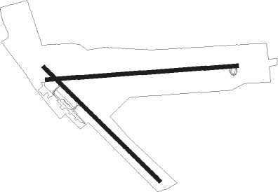
Runway info
Runway 11 / 29  | ||
| length | 1433m (4701ft) | |
| bearing | 90° / 270° | |
| width | 30m (99ft) | |
| surface | asphalt | |
| displ threshold | 3m (10ft) / 0m (0ft) | |
| blast zone | 88m (289ft) / 0m (0ft) | |
| Runway 16 / 34 | ||
| length | 1221m (4006ft) | |
| bearing | 129° / 309° | |
| width | 30m (100ft) | |
| surface | asphalt | |
| blast zone | 255m (837ft) / 0m (0ft) | |
Nearby beacons
| code | identifier | dist | bearing | frequency |
|---|---|---|---|---|
| LNT | MILNOT (MILLINOCKET) NDB | 5.9 | 90° | 344 |
| MLT | MILLINOCKET VOR/DME | 8.3 | 109° | 117.90 |
| HUL | DME | 42.9 | 66° | 116.10 |
| PNN | DME | 45.8 | 108° | 114.30 |
| BGR | BANGOR VORTAC | 49 | 193° | 114.80 |
| BUP | BURNHAM (PITTSFIELD) NDB | 63.6 | 215° | 348 |
Instrument approach procedures
| runway | airway (heading) | route (dist, bearing) |
|---|---|---|
| RW11 | PEENK (90°) | PEENK 5900ft |
| RNAV | PEENK 5900ft ZAKTI (6mi, 90°) 4000ft TURTE (5mi, 90°) 2300ft KMLT (6mi, 91°) 452ft (4521mi, 124°) 808ft JEBIV (4509mi, 304°) 2300ft JEBIV (turn) | |
| RW29 | JEBIV (270°) | JEBIV 2300ft |
| RNAV | JEBIV 2300ft IVVEW (7mi, 270°) 2300ft KMLT (7mi, 270°) 446ft (4521mi, 124°) 920ft JEBIV (4509mi, 304°) 2300ft JEBIV (turn) |
Disclaimer
The information on this website is not for real aviation. Use this data with the X-Plane flight simulator only! Data taken with kind consent from X-Plane 12 source code and data files. Content is subject to change without notice.