Minneapolis - Crystal
Airport details
| Country | United States of America |
| State | Minnesota |
| Region | K3 |
| Airspace | Minneapolis Ctr |
| Municipality | Crystal |
| Elevation | 869ft (265m) |
| Timezone | GMT -6 |
| Coordinates | 45.06200, -93.35394 |
| Magnetic var | |
| Type | land |
| Available since | X-Plane v10.40 |
| ICAO code | KMIC |
| IATA code | MIC |
| FAA code | MIC |
Communication
| Crystal ATIS | 124.475 |
| Crystal CTAF | 120.700 |
| Crystal UNICOM | 122.950 |
| Crystal Ground Control | 121.600 |
| Crystal Tower | 120.700 |
| Crystal MINNEAPOLIS Approach/Departure | 126.500 |
Nearby Points of Interest:
Robbinsdale Library
-Lawrence A. and Mary Fournier House
-Banfill Tavern
-Fredrika Bremer Intermediate School
-Osseo Water Tower
-Minneapolis Public Library, North Branch
-John Lohmar House
-North East Neighborhood House
-Ripley Memorial Hospital
-Sumner Library
-Little Sisters of the Poor Home for the Aged
-Hollywood Theater
-Northwestern Knitting Company Factory building
-Traffic Zone Center for Visual Art
-Foss House
-Butler Square
-Cowles Center for Dance and the Performing Arts
-Minneapolis Fire Department Repair Shop
-Lumber Exchange Building
-Swinford Townhouses and Apartments
-Plymouth Building
-Pence Automobile Company Building
-Lincoln Bank Building
-Forum Cafeteria
-Minneapolis YMCA Central Building
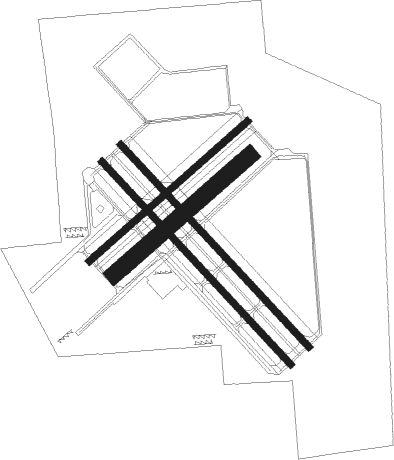
Runway info
Runway 14R / 32L  | ||
| length | 995m (3264ft) | |
| bearing | 132° / 312° | |
| width | 23m (75ft) | |
| surface | asphalt | |
| Runway 14L / 32R | ||
| length | 994m (3261ft) | |
| bearing | 132° / 312° | |
| width | 23m (75ft) | |
| surface | asphalt | |
| blast zone | 152m (499ft) / 152m (499ft) | |
| Runway 6L / 24R | ||
| length | 761m (2497ft) | |
| bearing | 62° / 242° | |
| width | 23m (75ft) | |
| surface | asphalt | |
| displ threshold | 119m (390ft) / 119m (390ft) | |
| Runway 06R / 24L | ||
| length | 646m (2119ft) | |
| bearing | 62° / 242° | |
| width | 62m (202ft) | |
| surface | grass | |
Nearby beacons
| code | identifier | dist | bearing | frequency |
|---|---|---|---|---|
| GEP | GOPHER (MINNEAPOLIS) VORTAC | 5 | 347° | 117.30 |
| MSP | MINNEAPOLIS VOR/DME | 11.1 | 145° | 115.30 |
| FCM | FLYING CLOUD (MINNEAPOLIS VOR/DME | 14.7 | 201° | 117.70 |
| FGT | FARMINGTON VORTAC | 26.9 | 158° | 115.70 |
| PNM | PRINCETON NDB | 32 | 333° | 368 |
| ST | HUSSK (ST CLOUD) NDB | 36 | 304° | 342 |
| RG | REGUE (RED WING) NDB | 41 | 123° | 274 |
| ROS | RUSH CITY NDB | 41.6 | 32° | 282 |
| STC | SAINT CLOUD VOR/DME | 41.7 | 305° | 112.10 |
| FOW | HALFWAY (MORRISTOWN) VOR/DME | 51.5 | 181° | 111.20 |
| MKT | MANKATO VOR/DME | 55.9 | 214° | 110.80 |
| OW | TONNA (OWATONNA) NDB | 59.9 | 169° | 379 |
| RZN | DME | 61.4 | 52° | 109.40 |
| BXR | BIG DOCTOR (SIREN) NDB | 61.7 | 52° | 203 |
Departure and arrival routes
| Transition altitude | 18000ft |
| Transition level | 18000ft |
| STAR starting points | distance | inbound heading | |
|---|---|---|---|
| ALL | |||
| ENCEE2 | 93.0 | 77° | |
| GEP1 | 44.0 | 153° | |
| AGUDE5 | 40.9 | 266° | |
Instrument approach procedures
| runway | airway (heading) | route (dist, bearing) |
|---|---|---|
| RW14 | JEMEF (104°) | JEMEF OYNOP (7mi, 60°) 3000ft |
| RW14 | OYNOP (132°) | OYNOP 3000ft |
| RW14 | ZAPIN (156°) | ZAPIN OYNOP (11mi, 185°) 3000ft |
| RNAV | OYNOP 3000ft ZUNBE (7mi, 131°) 2500ft KMIC (4mi, 132°) 906ft (5547mi, 116°) 1269ft GEP (5548mi, 296°) 3100ft GEP (turn) 3100ft | |
| RW32 | EPADE (274°) | EPADE 3500ft |
| RW32 | WAKUD (252°) | WAKUD EPADE (6mi, 196°) 3500ft |
| RNAV | EPADE 3500ft CATLE (3mi, 264°) 3000ft ZUSGA (3mi, 264°) 2500ft FICGO (3mi, 286°) 1189ft (5547mi, 116°) 1269ft OYNOP (5554mi, 296°) 3000ft OYNOP (turn) |
Holding patterns
| STAR name | hold at | type | turn | heading* | altitude | leg | speed limit |
|---|---|---|---|---|---|---|---|
| AGUDE5 | BEERI | VHF | right | 127 (307)° | 1.0min timed | ICAO rules | |
| ENCEE2 | WOOOD | VHF | left | 251 (71)° | < 17999ft | DME 10.0mi | ICAO rules |
| GEP1 | GOLLF | VHF | left | 333 (153)° | < 17999ft | 1.0min timed | ICAO rules |
| TWOLF3 | TWOLF | VHF | left | 178 (358)° | < 17999ft | 1.0min timed | ICAO rules |
| *) magnetic outbound (inbound) holding course | |||||||
Disclaimer
The information on this website is not for real aviation. Use this data with the X-Plane flight simulator only! Data taken with kind consent from X-Plane 12 source code and data files. Content is subject to change without notice.