Terre Haute - Terre Haute Rgnl
Airport details
| Country | United States of America |
| State | Indiana |
| Region | K5 |
| Airspace | Indianapolis Ctr |
| Municipality | Terre Haute |
| Elevation | 586ft (179m) |
| Timezone | GMT -5 |
| Coordinates | 39.45147, -87.30759 |
| Magnetic var | |
| Type | land |
| Available since | X-Plane v10.40 |
| ICAO code | KHUF |
| IATA code | HUF |
| FAA code | HUF |
Communication
| Terre Haute Rgnl ATIS | 127.500 |
| Terre Haute Rgnl UNICOM | 122.950 |
| Terre Haute Rgnl Ground Control | 121.600 |
| Terre Haute Rgnl Tower | 118.300 |
| Terre Haute Rgnl Approach/Departure | 119.800 |
| Terre Haute Rgnl Approach/Departure | 125.450 |
Approach frequencies
| ILS-cat-I | RW05 | 109.7 | 18.00mi |
| 3° GS | RW05 | 109.7 | 18.00mi |
Nearby Points of Interest:
Vigo County Home for Dependent Children
-Butternut Hill
-Ohio Boulevard-Deming Park Historic District
-Terre Haute Fire Station No. 8
-Booker T. Washington School
-Fire Station No. 9
-House at 209–211 S. Ninth Street
-House at 823 Ohio Street
-Terminal Arcade
-810 Wabash Avenue
-Wabash Theater
-Wabash Avenue-East Historic District
-Terre Haute Masonic Temple
-Indiana Theatre
-Eugene V. Debs Home
-Terre Haute Post Office and Federal Building
-Sage-Robinson-Nagel House
-Chamber of Commerce Building
-Condit House
-Star Building
-Citizens' Trust Company Building
-Building at 23–27 S. Sixth Street
-Building at 510–516 Ohio Street
-Williams-Warren-Zimmerman House
-First National Bank
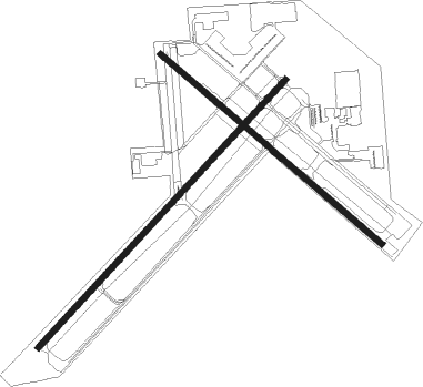
Runway info
Runway 5 / 23  | ||
| length | 2748m (9016ft) | |
| bearing | 54° / 234° | |
| width | 46m (150ft) | |
| surface | asphalt | |
| blast zone | 255m (837ft) / 255m (837ft) | |
| Runway 14 / 32 | ||
| length | 2194m (7198ft) | |
| bearing | 128° / 308° | |
| width | 46m (150ft) | |
| surface | asphalt | |
| blast zone | 0m (0ft) / 122m (400ft) | |
Nearby beacons
| code | identifier | dist | bearing | frequency |
|---|---|---|---|---|
| TTH | TERRE HAUTE VORTAC | 3.5 | 57° | 115.30 |
| HU | YINNO (TERRE HAUTE) NDB | 5.6 | 235° | 245 |
| PLX | PALESTINE (ROBINSON) NDB | 30.5 | 217° | 391 |
| CFJ | CRAWFORDSVILLE NDB | 36.5 | 37° | 388 |
| OOM | HOOSIER (BLOOMINGTON) VORTAC | 37.1 | 114° | 110.20 |
| LWV | DME | 43.2 | 203° | 108.80 |
| MTO | DME | 45.4 | 272° | 109.40 |
| VHP | BRICKYARD VORTAC | 48.6 | 69° | 116.30 |
| CM | VEALS (CHAMPAIGN/URBANA) NDB | 50.8 | 300° | 407 |
| DN | JULIP (DANVILLE) NDB | 51.3 | 345° | 332 |
| DNV | DANVILLE VORTAC | 51.8 | 343° | 111 |
| CMI | CHAMPAIGN VORTAC | 56.8 | 301° | 110 |
| LA | EARLE (LAFAYETTE) NDB | 59.7 | 15° | 401 |
| OLY | OLNEY NDB | 59.7 | 230° | 272 |
| SAM | SAMSVILLE VOR/DME | 68.4 | 219° | 116.60 |
Instrument approach procedures
| runway | airway (heading) | route (dist, bearing) |
|---|---|---|
| RW05 | GOZUM (3°) | GOZUM POKHY (11mi, 307°) 2600ft |
| RW05 | IFIGO (83°) | IFIGO POKHY (8mi, 125°) 2600ft |
| RW05 | TTH (237°) | TTH POKHY (15mi, 235°) 2600ft POKHY (turn) 2600ft |
| RNAV | POKHY 2600ft SOXME (6mi, 54°) 2100ft VARUY (3mi, 54°) 1140ft KHUF (3mi, 55°) 612ft (5280mi, 114°) 880ft IPEDY (5271mi, 294°) 2400ft IPEDY (turn) | |
| RW14 | CUDAN (108°) | CUDAN JOSTO (5mi, 52°) 2600ft |
| RW14 | ENOCU (154°) | ENOCU JOSTO (5mi, 232°) 2600ft |
| RW14 | JOSTO (129°) | JOSTO 6000ft JOSTO (turn) 2600ft |
| RNAV | JOSTO 2600ft FETOV (6mi, 128°) 2300ft KHUF (6mi, 130°) 623ft (5280mi, 114°) 980ft CORIE (5271mi, 294°) 2600ft CORIE (turn) | |
| RW23 | MATAN (247°) | MATAN IPEDY (7mi, 268°) 2400ft |
| RW23 | TTH (237°) | TTH IPEDY (9mi, 53°) 2400ft IPEDY (turn) 2400ft |
| RW23 | VANJI (201°) | VANJI IPEDY (8mi, 134°) 2400ft |
| RNAV | IPEDY 2400ft IMTEW (6mi, 234°) 2400ft CUVOS (4mi, 234°) 1160ft KHUF (2mi, 234°) 637ft (5280mi, 114°) 874ft POKHY (5289mi, 294°) 2600ft POKHY (turn) | |
| RW32 | CORIE (307°) | CORIE 6000ft CORIE (turn) 2600ft |
| RW32 | FOBKA (287°) | FOBKA CORIE (5mi, 232°) 2600ft |
| RW32 | KMETZ (331°) | KMETZ CORIE (5mi, 52°) 2600ft |
| RNAV | CORIE 2600ft APENY (6mi, 308°) 2300ft KHUF (6mi, 305°) 639ft (5280mi, 114°) 960ft JOSTO (5289mi, 294°) 2600ft JOSTO (turn) |
Disclaimer
The information on this website is not for real aviation. Use this data with the X-Plane flight simulator only! Data taken with kind consent from X-Plane 12 source code and data files. Content is subject to change without notice.