Hibbing - Range Regl
Airport details
| Country | United States of America |
| State | Minnesota |
| Region | K3 |
| Airspace | Minneapolis Ctr |
| Municipality | Hibbing |
| Elevation | 1354ft (413m) |
| Timezone | GMT -6 |
| Coordinates | 47.38659, -92.83897 |
| Magnetic var | |
| Type | land |
| Available since | X-Plane v10.40 |
| ICAO code | KHIB |
| IATA code | HIB |
| FAA code | HIB |
Communication
| Range Regl ASOS | 126.425 |
| Range Regl CTAF/UNICOM | 123.000 |
| Range Regl DULUTH Clearance DEL | 127.400 |
| Range Regl CTAF called TOWER | 123.000 |
| Range Regl DULUTH Approach/Departure | 125.450 |
Approach frequencies
| ILS-cat-I | RW31 | 108.75 | 18.00mi |
| ILS-cat-I | RW13 | 111.75 | 18.00mi |
| 3° GS | RW13 | 111.75 | 18.00mi |
| 2.9° GS | RW31 | 108.75 | 18.00mi |
Nearby Points of Interest:
Sons of Italy Hall
-Mitchell–Tappan House
-Hibbing City Hall
-Bruce Mine Headframe
-Saints Peter and Paul Church-Ukrainian Catholic
-Chisholm Commercial Historic District
-Buhl City Hall
-Church of the Holy Family
-W. Bailey House
-Coates House
-W.T. Bailey House
-Virginia Depot
-B'nai Abraham Synagogue
-St. Louis County District Courthouse
-Charles Lenont House
-Church of St. John the Baptist
-Virginia–Rainy Lake Lumber Company Office
-Lincoln School Building
-Jukola Boardinghouse
-Finnish Sauna
-Hill-Annex Mine State Park
-Church of St. Joseph
-Western Bohemian Fraternal Union Hall
-Camp Esquagama
-Coleraine Methodist Episcopal Church
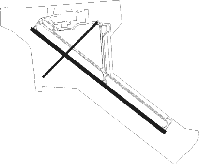
Runway info
Runway 13 / 31  | ||
| length | 2057m (6749ft) | |
| bearing | 122° / 302° | |
| width | 46m (150ft) | |
| surface | asphalt | |
| blast zone | 61m (200ft) / 58m (190ft) | |
| Runway 4 / 22 | ||
| length | 936m (3071ft) | |
| bearing | 60° / 240° | |
| width | 23m (75ft) | |
| surface | asphalt | |
| blast zone | 26m (85ft) / 0m (0ft) | |
Nearby beacons
| code | identifier | dist | bearing | frequency |
|---|---|---|---|---|
| HIB | HIBBING VOR/DME | 7.4 | 122° | 110.80 |
| GPZ | GRAND RAPIDS VOR/DME | 29.6 | 251° | 111.40 |
| DL | PYKLA (DULUTH) NDB | 38 | 138° | 379 |
| FOZ | BIGFORK NDB | 40.6 | 296° | 345 |
| LKI | LAKESIDE (DULUTH) TACAN | 42.1 | 130° | 135.40 |
| DLH | DULUTH VORTAC | 43.6 | 133° | 112.60 |
| SCG | SCOTT (CRANE LAKE) NDB | 54.4 | 23° | 385 |
Instrument approach procedures
| runway | airway (heading) | route (dist, bearing) |
|---|---|---|
| RW04 | RITOC (79°) | RITOC 3500ft SEYOP (5mi, 128°) 3500ft |
| RW04 | SEYOP (61°) | SEYOP 3500ft |
| RW04 | YIPUD (36°) | YIPUD 3500ft SEYOP (5mi, 308°) 3500ft |
| RNAV | SEYOP 3500ft JUBIK (6mi, 60°) 3000ft KHIB (5mi, 62°) 1394ft (5521mi, 117°) 1780ft SAGOY (5511mi, 297°) 3500ft SAGOY (turn) | |
| RW13 | FENOK (121°) | FENOK 3500ft |
| RNAV | FENOK 3500ft DULEC (7mi, 121°) 3300ft OLAYU (3mi, 122°) 2180ft KHIB (3mi, 121°) 1402ft (5521mi, 117°) 1604ft CEKSA (5511mi, 297°) 3500ft CEKSA (turn) | |
| RW22 | SAGOY (239°) | SAGOY 3500ft |
| RW22 | WALDU (257°) | WALDU 3500ft SAGOY (5mi, 309°) 3500ft |
| RW22 | ZENAK (216°) | ZENAK 3500ft SAGOY (5mi, 128°) 3500ft |
| RNAV | SAGOY 3500ft PEKOY (6mi, 240°) 3300ft KHIB (6mi, 238°) 1397ft (5521mi, 117°) 1753ft SEYOP (5529mi, 297°) 3500ft SEYOP (turn) | |
| RW31 | CEKSA (302°) | CEKSA 3500ft |
| RNAV | CEKSA 3500ft AYADO (7mi, 302°) 3300ft HIBDA (4mi, 302°) 1860ft KHIB (2mi, 302°) 1393ft (5521mi, 117°) 1538ft FENOK (5530mi, 297°) 3500ft FENOK (turn) |
Disclaimer
The information on this website is not for real aviation. Use this data with the X-Plane flight simulator only! Data taken with kind consent from X-Plane 12 source code and data files. Content is subject to change without notice.