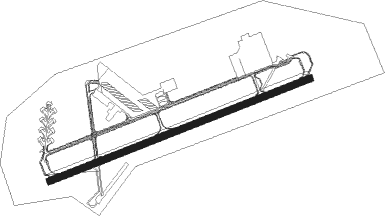
Goldsboro - Seymour Johnson Afb
Airport details
| Country | United States of America |
| State | North Carolina |
| Region | K7 |
| Airspace | Washington Ctr |
| Municipality | Goldsboro |
| Elevation | 108ft (33m) |
| Timezone | GMT -5 |
| Coordinates | 35.33939, -77.96059 |
| Magnetic var | |
| Type | land |
| Available since | X-Plane v10.40 |
| ICAO code | KGSB |
| IATA code | GSB |
| FAA code | GSB |
Communication
| Seymour Johnson AFB Clearance DEL | 128.025 |
| Seymour Johnson AFB Tower | 126.250 |
| Seymour Johnson AFB Approach | 123.700 |
| Seymour Johnson AFB Approach | 119.700 |
| Seymour Johnson AFB Departure | 119.700 |
| Seymour Johnson AFB Departure | 123.700 |
Approach frequencies
| ILS-cat-I | RW26 | 109.9 | 18.00mi |
| ILS-cat-I | RW08 | 109.3 | 18.00mi |
| 3° GS | RW26 | 109.9 | 18.00mi |
| 3° GS | RW08 | 109.3 | 18.00mi |
Nearby beacons
| code | identifier | dist | bearing | frequency |
|---|---|---|---|---|
| GSB | SEYMOUR JOHNSON TACAN | 0.5 | 249° | 116.50 |
| IS | STALS (KINSTON) NDB | 14 | 110° | 276 |
| ISO | KINSTON VORTAC | 19.7 | 86° | 109.60 |
| JN | JURLY (SMITHFIELD) NDB | 24.1 | 286° | 263 |
| CTZ | CLINTON NDB | 29.4 | 228° | 412 |
| HQT | HARNETT (ERWIN) NDB | 35.4 | 277° | 417 |
| AQE | ALWOOD (GREENVILLE) NDB | 36.2 | 58° | 230 |
| OA | ELLAS (JACKSONVILLE) NDB | 37.5 | 156° | 261 |
| TYI | TAR RIVER (ROCKY MOUNT) VORTAC | 40.2 | 22° | 117.80 |
| RNW | CHOCOWINITY NDB | 43 | 79° | 388 |
| FGP | FORT BRAGG NDB | 43.4 | 257° | 393 |
| NCA | NEW RIVER TACAN | 45.7 | 141° | 115.40 |
| EW | KAFTI (NEW BERN) NDB | 47.2 | 110° | 362 |
| EWN | NEW BERN VOR/DME | 47.6 | 106° | 113.60 |
| POB | POPE (FAYETTEVILLE) NDB | 49.1 | 264° | 338 |
| FAY | FAYETTEVILLE VOR/DME | 49.6 | 249° | 108.80 |
| LE | LEEVY (RALEIGH/DURHAM) NDB | 51.2 | 308° | 350 |
| RDU | RALEIGH-DURHAM VORTAC | 51.3 | 303° | 117.20 |
| DIW | DIXON NDB | 52.6 | 147° | 198 |
| ILM | WILMINGTON VORTAC | 59.4 | 175° | 117 |
| HXO | HUNTSBORO (OXFORD) NDB | 66 | 326° | 271 |
Instrument approach procedures
| runway | airway (heading) | route (dist, bearing) |
|---|---|---|
| RW08 | PHNTM (76°) | PHNTM 4000ft TULME (8mi, 76°) 2500ft |
| RNAV | TULME 2500ft WODIP (7mi, 76°) 1600ft FABOT (2mi, 76°) 860ft KGSB (3mi, 76°) 128ft (4817mi, 114°) 509ft ZILOB (4806mi, 294°) 2300ft ZILOB (turn) 4000ft | |
| RW26 | EEGEL (256°) | EEGEL 4000ft ZILOB (18mi, 256°) 2500ft |
| RNAV | ZILOB 2500ft WILBI (6mi, 256°) 1600ft HALNO (2mi, 256°) 860ft KGSB (3mi, 256°) 164ft (4817mi, 114°) 509ft TULME (4828mi, 294°) 2200ft TULME (turn) 6000ft |
Disclaimer
The information on this website is not for real aviation. Use this data with the X-Plane flight simulator only! Data taken with kind consent from X-Plane 12 source code and data files. Content is subject to change without notice.
