Logansport - Logansport Cass Co
Airport details
| Country | United States of America |
| State | Indiana |
| Region | K5 |
| Airspace | Chicago Ctr |
| Municipality | Logansport |
| Elevation | 735ft (224m) |
| Timezone | GMT -5 |
| Coordinates | 40.71128, -86.37270 |
| Magnetic var | |
| Type | land |
| Available since | X-Plane v10.40 |
| ICAO code | KGGP |
| IATA code | n/a |
| FAA code | GGP |
Communication
| Logansport Cass CO AWOS-3P | 118.500 |
| Logansport Cass CO CTAF/UNICOM | 122.800 |
| Logansport Cass CO GRISSOM Approach/Departure | 121.050 |
Nearby Points of Interest:
Point Historic District
-Bankers Row Historic District
-Pollard-Nelson House
-Courthouse Historic District
-Kendrick-Baldwin House
-Ferguson House
-Willard B. Place House
-Jerolaman-Long House
-Henry Tousley House
-John Keip House
-Josephus Atkinson Farm
-Thompson Barnett House
-District School No. 3
-Burris House and Potawatomi Spring
-Andrew Thomas House
-Camden Masonic Temple
-Terrell Jacobs Circus Winter Quarters
-44-83690
-Fred and Minnie Raber Farm
-Wilson Bridge
-Deer Creek Valley Rural Historic District
-Shirk-Edwards House
-Peru High School Historic District
-Brownell Block/Senger Dry Goods Company Building
-James Omar Cole House
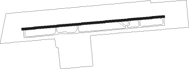
Runway info
| Runway 9 / 27 | ||
| length | 1523m (4997ft) | |
| bearing | 90° / 270° | |
| width | 23m (75ft) | |
| surface | asphalt | |
| blast zone | 158m (518ft) / 0m (0ft) | |
Nearby beacons
| code | identifier | dist | bearing | frequency |
|---|---|---|---|---|
| GUS | GRISSOM (PERU) VORTAC | 10.8 | 107° | 108.45 |
| OKK | KOKOMO VORTAC | 18 | 120° | 113.50 |
| BVT | BOILER (LAFAYETTE) VORTAC | 33 | 257° | 115.10 |
| MZZ | MARION VOR/DME | 34.2 | 107° | 108.60 |
| LA | EARLE (LAFAYETTE) NDB | 35.4 | 247° | 401 |
| OXI | KNOX VOR/DME | 38.7 | 336° | 115.60 |
| UMP | METROPOLITAN (INDIANAPOLIS) NDB | 48.7 | 157° | 338 |
| VP | SEDLY (VALPARAISO) NDB | 49.9 | 326° | 212 |
| CFJ | CRAWFORDSVILLE NDB | 50.4 | 217° | 388 |
| OLK | WEBSTER LAKE VOR | 51 | 59° | 110.40 |
| GSH | GOSHEN VORTAC | 51.3 | 23° | 113.70 |
| MIE | MUNCIE VOR/DME | 53 | 116° | 114.40 |
| VHP | BRICKYARD VORTAC | 53.8 | 180° | 116.30 |
| AI | VIDEO (ANDERSON) NDB | 55.1 | 127° | 394 |
| FV | LAREZ (INDIANAPOLIS) NDB | 56.1 | 169° | 349 |
| SB | MISHA (SOUTH BEND) NDB | 60.1 | 9° | 341 |
| GY | GARIE (GARY) NDB | 67.3 | 312° | 236 |
Instrument approach procedures
| runway | airway (heading) | route (dist, bearing) |
|---|---|---|
| RW09 | BVT (77°) | BVT DATEC (22mi, 71°) 2500ft |
| RW09 | DATEC (89°) | DATEC 2500ft |
| RW09 | MONON (103°) | MONON DATEC (15mi, 113°) 2500ft |
| RNAV | DATEC 2500ft CEAST (6mi, 89°) 2400ft DOSAY (3mi, 89°) 1300ft KGGP (2mi, 89°) 776ft (5240mi, 115°) 1200ft MONON (5265mi, 295°) 2500ft MONON (turn) | |
| RW27 | MZZ (287°) | MZZ WENGO (24mi, 297°) 2400ft |
| RW27 | TELEY (249°) | TELEY WENGO (31mi, 240°) 2400ft |
| RNAV | WENGO 2400ft EJAJY (6mi, 270°) 2400ft JIPID (3mi, 270°) 1560ft KGGP (3mi, 270°) 778ft (5240mi, 115°) 938ft DATEC (5252mi, 295°) 2500ft DATEC (turn) |
Disclaimer
The information on this website is not for real aviation. Use this data with the X-Plane flight simulator only! Data taken with kind consent from X-Plane 12 source code and data files. Content is subject to change without notice.