Charlotte - Fitch H Beach
Airport details
| Country | United States of America |
| State | Michigan |
| Region | K5 |
| Airspace | Cleveland Ctr |
| Municipality | Charlotte |
| Elevation | 891ft (272m) |
| Timezone | GMT -5 |
| Coordinates | 42.57409, -84.81211 |
| Magnetic var | |
| Type | land |
| Available since | X-Plane v10.40 |
| ICAO code | KFPK |
| IATA code | n/a |
| FAA code | FPK |
Communication
| Fitch H Beach AWOS 3 | 118.075 |
| Fitch H Beach CTAF/UNICOM | 123.000 |
| Fitch H Beach LANSING Approach/Departure | 118.650 |
Nearby Points of Interest:
Charlotte station
-Courthouse Square Museum
-Charlotte Central Historic District
-First Congregational Church
-Isaac N. Reynolds House
-Hance House
-Darius B. Moon House
-Elliott-Larsen Building
-Charles E. Chamberlain Federal Building & Post Office
-Somerville Barn
-J.W. Knapp Company Building
-Masonic Temple Building
-Boji Tower
-Strand Theatre and Arcade
-First Baptist Church
-Michigan Millers Mutual Fire Insurance Company Building
-Lansing Woman's Club Building
-Christman Building
-Ottawa Street Power Station
-Lansing Civil Air Patrol Quonset Huts
-Union Depot
-Smith-Turner House
-Brown-Price House
-Pulver Brothers Filling Station
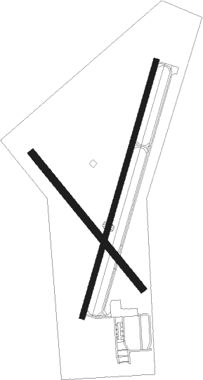
Runway info
Runway 3 / 21  | ||
| length | 1071m (3514ft) | |
| bearing | 27° / 207° | |
| width | 23m (75ft) | |
| surface | concrete | |
| Runway 15 / 33 | ||
| length | 701m (2300ft) | |
| bearing | 137° / 317° | |
| width | 29m (95ft) | |
| surface | grass | |
| displ threshold | 173m (568ft) / 58m (190ft) | |
Nearby beacons
| code | identifier | dist | bearing | frequency |
|---|---|---|---|---|
| BT | BATOL (BATTLE CREEK) NDB | 20.8 | 240° | 272 |
| JXN | DME | 24.5 | 132° | 115.45 |
| LFD | LITCHFIELD VOR/DME | 30.7 | 175° | 111.20 |
| GR | KNOBS (GRAND RAPIDS) NDB | 31.5 | 300° | 263 |
| VIO | VICTORY VOR/DME | 32.8 | 287° | 115.95 |
| AZO | KALAMAZOO VOR/DME | 38.5 | 246° | 109 |
| AZ | AUSTN (KALAMAZOO) NDB | 41.4 | 238° | 371 |
| TCU | TECUMSEH NDB | 52.3 | 120° | 239 |
| ADG | ADRIAN NDB | 53.4 | 134° | 278 |
| IRS | STURGIS NDB | 53.4 | 219° | 382 |
| MB | OLSTE (SAGINAW) NDB | 60 | 35° | 257 |
| MBS | SAGINAW VOR/DME | 65.9 | 38° | 112.90 |
Instrument approach procedures
| runway | airway (heading) | route (dist, bearing) |
|---|---|---|
| RW21 | ERRYS (247°) | ERRYS LUYRI (26mi, 259°) 3000ft |
| RW21 | LESSY (298°) | LESSY LUYRI (20mi, 331°) 3000ft LUYRI (turn) 3000ft |
| RW21 | UNSUN (123°) | UNSUN LUYRI (16mi, 90°) 3000ft LUYRI (turn) 3000ft |
| RNAV | LUYRI 3000ft HURES (7mi, 207°) 2500ft KFPK (4mi, 207°) 931ft (5176mi, 117°) 1300ft LESSY (5164mi, 297°) 3000ft LESSY (turn) |
Disclaimer
The information on this website is not for real aviation. Use this data with the X-Plane flight simulator only! Data taken with kind consent from X-Plane 12 source code and data files. Content is subject to change without notice.