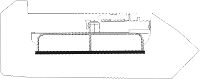
Fort Meade(odenton) - Tipton
Airport details
| Country | United States of America |
| State | Maryland |
| Region | K6 |
| Airspace | Washington Ctr |
| Municipality | Anne Arundel County |
| Elevation | 148ft (45m) |
| Timezone | GMT -5 |
| Coordinates | 39.08644, -76.76235 |
| Magnetic var | |
| Type | land |
| Available since | X-Plane v10.40 |
| ICAO code | KFME |
| IATA code | FME |
| FAA code | FME |
Communication
| Tipton AWOS | 123.925 |
| Tipton CTAF / UNICOM | 123.050 |
| Tipton TOWER | 123.050 |
| Tipton POTOMAC Approach | 119.700 |
| Tipton POTOMAC Departure | 119.700 |
Runway info
| Runway 10 / 28 | ||
| length | 912m (2992ft) | |
| bearing | 93° / 273° | |
| width | 23m (75ft) | |
| surface | asphalt | |
Nearby beacons
| code | identifier | dist | bearing | frequency |
|---|---|---|---|---|
| BUH | ANNE ARUNDEL (FT MEADE) NDB | 0.1 | 135° | 260 |
| BAL | BALTIMORE VORTAC | 6.9 | 50° | 115.10 |
| FND | ELLICOTT (BALTIMORE) NDB | 12 | 356° | 371 |
| ADW | ANDREWS (CAMP SPRINGS) VORTAC | 17.4 | 200° | 113.10 |
| DCA | WASHINGTON, D.C. VOR/DME | 18.6 | 230° | 111 |
| GTN | GEORGETOWN (WASH., D.C.) NDB | 19.3 | 247° | 323 |
| MTN | MARTIN (BALTIMORE) TACAN | 21.9 | 55° | 134.10 |
| DCA | OXONN (WASHINGTON) NDB | 22.8 | 220° | 332 |
| OTT | NOTTINGHAM VORTAC | 22.8 | 177° | 113.70 |
| EMI | WESTMINSTER VORTAC | 26.5 | 332° | 117.90 |
| DAA | DAVEE (FT BELVOIR) NDB | 30.2 | 219° | 223 |
| AML | ARMEL (WASH.,D.C.) VOR/DME | 34.1 | 258° | 113.50 |
| FDK | FREDERICK VOR | 34.5 | 298° | 109 |
| PXT | PATUXENT (PATUXENT RIVER) VORTAC | 50.8 | 156° | 117.60 |
| NHK | PATUXENT NDB | 50.9 | 156° | 400 |
| NHK | NAS PATUXENT RIVER TACAN | 51.1 | 156° | 110.25 |
| BRV | BROOKE VORTAC | 52.8 | 218° | 114.50 |
| EZF | SHANNON (FREDERICKSBURG) NDB | 58.8 | 220° | 237 |
Instrument approach procedures
| runway | airway (heading) | route (dist, bearing) |
|---|---|---|
| RW10 | WOOLY (133°) | WOOLY CUTOP (11mi, 159°) 2100ft |
| RNAV | CUTOP 2100ft FATIR (7mi, 120°) 1600ft POGKI (4mi, 101°) 312ft (4791mi, 117°) 550ft HORTU (4789mi, 297°) GEEMO (11mi, 97°) 2200ft GEEMO (turn) | |
| RW28 | GEEMO (278°) | GEEMO 2200ft |
| RW28 | PALEO (279°) | PALEO GEEMO (7mi, 279°) 2200ft |
| RNAV | GEEMO 2200ft BEVGE (5mi, 284°) 2200ft FATEN (4mi, 273°) 800ft KFME (2mi, 274°) 190ft (4790mi, 117°) 550ft GEEMO (4778mi, 297°) 2200ft GEEMO (turn) |
Disclaimer
The information on this website is not for real aviation. Use this data with the X-Plane flight simulator only! Data taken with kind consent from X-Plane 12 source code and data files. Content is subject to change without notice.
