Fayetteville - Fayetteville Rgnl Grannis Fld
Airport details
| Country | United States of America |
| State | North Carolina |
| Region | K7 |
| Airspace | Washington Ctr |
| Municipality | Fayetteville |
| Elevation | 187ft (57m) |
| Timezone | GMT -5 |
| Coordinates | 34.98465, -78.87913 |
| Magnetic var | |
| Type | land |
| Available since | X-Plane v10.40 |
| ICAO code | KFAY |
| IATA code | FAY |
| FAA code | FAY |
Communication
| Fayetteville Rgnl Grannis Fld ATIS | 121.250 |
| Fayetteville Rgnl Grannis Fld UNICOM | 122.950 |
| Fayetteville Rgnl Grannis Fld Tower | 118.300 |
| Fayetteville Rgnl Grannis Fld Ground Control | 121.700 |
| Fayetteville Rgnl Grannis Fld Approach | 125.175 |
| Fayetteville Rgnl Grannis Fld Departure | 125.175 |
Approach frequencies
| ILS-cat-I | RW04 | 110.5 | 18.00mi |
| 3° GS | RW04 | 110.5 | 18.00mi |
Nearby Points of Interest:
Hope Mills Historic District
-Dr. Ezekiel Ezra Smith House
-William McDiarmid House
-Heritage Square
-Sedberry-Holmes House
-Cumberland County Courthouse
-Liberty Row
-Cape Fear and Yadkin Valley Railway Passenger Depot
-Cool Spring Place
-Market House Square District
-Fayetteville Downtown Historic District
-M & O Chevrolet Company
-Waddill's Store
-Fayetteville Mutual Insurance Company Building
-The Capitol
-St. John's Episcopal Church
-Mansard Roof House
-Phoenix Masonic Lodge No. 8
-Kyle House
-St. Joseph's Episcopal Church
-McCall House
-Holt-Harrison House
-Brownlea
-Dr. William C. Verdery House
-Belden-Horne House
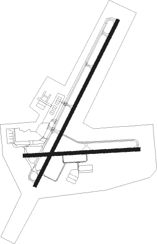
Runway info
Runway 4 / 22  | ||
| length | 2354m (7723ft) | |
| bearing | 36° / 216° | |
| width | 46m (150ft) | |
| surface | asphalt | |
| displ threshold | 182m (597ft) / 92m (302ft) | |
| blast zone | 0m (0ft) / 29m (95ft) | |
| Runway 10 / 28 | ||
| length | 1460m (4790ft) | |
| bearing | 91° / 271° | |
| width | 46m (150ft) | |
| surface | asphalt | |
Nearby beacons
| code | identifier | dist | bearing | frequency |
|---|---|---|---|---|
| FAY | FAYETTEVILLE VOR/DME | 0.2 | 78° | 108.80 |
| FGP | FORT BRAGG NDB | 9.8 | 23° | 393 |
| POB | POPE (FAYETTEVILLE) TACAN | 13 | 323° | 113.80 |
| POB | POPE (FAYETTEVILLE) NDB | 15 | 343° | 338 |
| CTZ | CLINTON NDB | 25.4 | 91° | 412 |
| HQT | HARNETT (ERWIN) NDB | 28.7 | 25° | 417 |
| JB | JIGEL (LUMBERTON) NDB | 29.2 | 211° | 384 |
| ME | MAXTN (MAXTON) NDB | 31.6 | 246° | 257 |
| JN | JURLY (SMITHFIELD) NDB | 36.9 | 43° | 263 |
| SDZ | SANDHILLS (SOUTHERN PINES VORTAC | 37.4 | 288° | 111.80 |
| DLC | DILLON NDB | 40.1 | 222° | 274 |
| CPC | CAMP (WHITEVILLE) NDB | 43.5 | 167° | 227 |
| BES | BENNETTSVILLE NDB | 47.4 | 247° | 230 |
| GSB | SEYMOUR JOHNSON TACAN | 49.2 | 69° | 116.50 |
| RDU | RALEIGH-DURHAM VORTAC | 53.5 | 6° | 117.20 |
| LE | LEEVY (RALEIGH/DURHAM) NDB | 57.1 | 9° | 350 |
| FLO | FLORENCE VORTAC | 59.3 | 226° | 115.20 |
| LIB | LIBERTY VORTAC | 61.2 | 318° | 113 |
| FL | ALCOT (FLORENCE) NDB | 68.4 | 230° | 335 |
| HB | ALAMM NDB | 68.9 | 325° | 361 |
Instrument approach procedures
| runway | airway (heading) | route (dist, bearing) |
|---|---|---|
| RW04 | ZODGI (38°) | ZODGI 6000ft ZODGI (turn) 2300ft |
| RNAV | ZODGI 2300ft CINLO (7mi, 36°) 1900ft YISBU (3mi, 36°) 800ft KFAY (2mi, 46°) 230ft (4859mi, 114°) 389ft UJORO (4854mi, 294°) 2300ft UJORO (turn) | |
| RW10 | ROWEL (46°) | ROWEL WALEX (9mi, 4°) 2600ft SUGAE (5mi, 4°) 2600ft |
| RW10 | SUGAE (80°) | SUGAE 14000ft SUGAE (turn) 2600ft |
| RNAV | SUGAE 2600ft ZITMO (8mi, 76°) 2100ft HEDUR (5mi, 81°) 383ft (4860mi, 114°) 589ft JAGOB (4849mi, 294°) 2600ft JAGOB (turn) | |
| RW22 | UJORO (215°) | UJORO 6000ft UJORO (turn) 2300ft |
| RNAV | UJORO 2300ft MORGY (7mi, 216°) 1800ft KFAY (6mi, 213°) 208ft (4859mi, 114°) 360ft ZODGI (4865mi, 294°) 2300ft ZODGI (turn) | |
| RW28 | CENKO (249°) | CENKO JAGOB (5mi, 182°) 2600ft |
| RW28 | JAGOB (270°) | JAGOB 14000ft JAGOB (turn) 2600ft |
| RW28 | NISIE (292°) | NISIE JAGOB (5mi, 2°) 2600ft |
| RNAV | JAGOB 2600ft FIKUL (5mi, 271°) 1900ft KFAY (6mi, 269°) 219ft (4859mi, 114°) 500ft FIDBO (4861mi, 294°) SUGAE (12mi, 257°) 2600ft SUGAE (turn) |
Disclaimer
The information on this website is not for real aviation. Use this data with the X-Plane flight simulator only! Data taken with kind consent from X-Plane 12 source code and data files. Content is subject to change without notice.