Houston - Weiser Air Park
Airport details
| Country | United States of America |
| State | Texas |
| Region | K4 |
| Airspace | Houston Oceanic Ctr |
| Municipality | Harris County |
| Elevation | 137ft (42m) |
| Timezone | GMT -6 |
| Coordinates | 29.93557, -95.63937 |
| Magnetic var | |
| Type | land |
| Available since | X-Plane v10.40 |
| ICAO code | KEYQ |
| IATA code | n/a |
| FAA code | EYQ |
Communication
| Weiser Air Park CTAF/UNICOM | 122.800 |
| Weiser Air Park HOUSTON Approach/Departure | 123.800 |
Nearby Points of Interest:
B. Ray and Charlotte Woods House
-David A. Carden House
-Houston Heights Waterworks Reservoir
-Charles Johnson House
-Ben C. and Jenetter Cyrus House
-Oscar Lindsay House
-Burge House
-Banta House
-Houston Heights Woman's Club
-Allbach House
-Barker House
-Gillette House
-Houston Heights Fire Station
-Otto H. Baring House
-Webber House
-All Saints Catholic Church
-Isbell House
-John W. Anderson House
-Heights State Bank Building
-Star Engraving Company building
-River Oaks Garden Club Forum of Civics
-Simon and Mamie Minchen House
-1879 Houston Waterworks
-Link–Lee House
-Boulevard Oaks
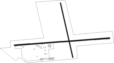
Runway info
Runway 9 / 27  | ||
| length | 1051m (3448ft) | |
| bearing | 90° / 270° | |
| width | 12m (40ft) | |
| surface | asphalt | |
| Runway 16 / 34 | ||
| length | 612m (2008ft) | |
| bearing | 170° / 350° | |
| width | 10m (33ft) | |
| surface | grass | |
Nearby beacons
| code | identifier | dist | bearing | frequency |
|---|---|---|---|---|
| IAH | HUMBLE (HOUSTON) VORTAC | 15.3 | 86° | 116.60 |
| BVP | NIXIN (HOUSTON) NDB | 22.3 | 82° | 326 |
| TNV | NAVASOTA VOR/DME | 30.3 | 310° | 115.90 |
| CX | ALIBI (HOUSTON) NDB | 30.9 | 18° | 281 |
| EFD | ELLINGTON (HOUSTON) TACAN | 31.8 | 124° | 109.40 |
| ELA | EAGLE LAKE VOR/DME | 38.9 | 248° | 116.40 |
| IDU | INDUSTRY VORTAC | 48 | 271° | 110.20 |
| UTS | HUNTSVILLE NDB | 48.4 | 3° | 308 |
| CL | ROWDY (COLLEGE STATION) NDB | 49.3 | 309° | 260 |
| MHF | TRINITY (SMITH POINT) VOR/DME | 52 | 114° | 113.60 |
| DAS | DAISETTA VORTAC | 53.8 | 76° | 116.90 |
| VUH | SCHOLES (GALVESTON) VOR/DME | 56.7 | 131° | 113 |
| CLL | COLLEGE STATION VORTAC | 57 | 311° | 113.30 |
Disclaimer
The information on this website is not for real aviation. Use this data with the X-Plane flight simulator only! Data taken with kind consent from X-Plane 12 source code and data files. Content is subject to change without notice.