Kenansville - Duplin Co
Airport details
| Country | United States of America |
| State | North Carolina |
| Region | K7 |
| Airspace | Washington Ctr |
| Municipality | Duplin County |
| Elevation | 137ft (42m) |
| Timezone | GMT -5 |
| Coordinates | 35.00006, -77.98170 |
| Magnetic var | |
| Type | land |
| Available since | X-Plane v10.40 |
| ICAO code | KDPL |
| IATA code | n/a |
| FAA code | DPL |
Communication
| Duplin Co AWOS 3 | 120.675 |
| Duplin Co CTAF/UNICOM | 123.000 |
| Duplin Co SEYMOUR JOHNSON Approach | 119.700 |
Nearby Points of Interest:
Joshua James Blanchard House
-Francis Pugh House
-Dell School Campus
-Gen. Thomas Boykin House
-Eagle Nest
-La Grange Historic District (North Carolina)
-La Grange Presbyterian Church
-Kennedy Memorial Home Historic District
-Cedar Dell
-Venters Farm Historic District
-Solomon and Henry Weil Houses
-L. D. Giddens and Son Jewelry Store
-Odd Fellows Lodge
-Goldsboro Union Station
-First Presbyterian Church
-Bentonville Battlefield
-Harper House
-Harmony Hall
-Robert L. Blalock House
-Baptist Parsonage
-Kinston Fire Station-City Hall
-Mitchelltown Historic District
-Queen-Gordon Streets Historic District
-B. W. Canady House
-Lenoir County Courthouse
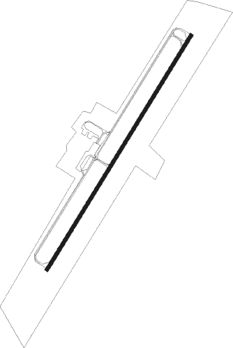
Runway info
| Runway 5 / 23 | ||
| length | 1831m (6007ft) | |
| bearing | 42° / 222° | |
| width | 23m (75ft) | |
| surface | asphalt | |
| blast zone | 18m (59ft) / 0m (0ft) | |
Nearby beacons
| code | identifier | dist | bearing | frequency |
|---|---|---|---|---|
| CTZ | CLINTON NDB | 18.7 | 266° | 412 |
| GSB | SEYMOUR JOHNSON TACAN | 20.1 | 2° | 116.50 |
| IS | STALS (KINSTON) NDB | 20.2 | 49° | 276 |
| OA | ELLAS (JACKSONVILLE) NDB | 20.2 | 132° | 261 |
| ISO | KINSTON VORTAC | 30.4 | 49° | 109.60 |
| NCA | NEW RIVER TACAN | 31.9 | 118° | 115.40 |
| JN | JURLY (SMITHFIELD) NDB | 35.8 | 317° | 263 |
| DIW | DIXON NDB | 36.7 | 129° | 198 |
| ILM | WILMINGTON VORTAC | 39.3 | 171° | 117 |
| GM | WILZE NDB | 40.6 | 166° | 205 |
| FGP | FORT BRAGG NDB | 41.6 | 279° | 393 |
| HQT | HARNETT (ERWIN) NDB | 42.8 | 302° | 417 |
| FAY | FAYETTEVILLE VOR/DME | 43.9 | 269° | 108.80 |
| EW | KAFTI (NEW BERN) NDB | 44.3 | 89° | 362 |
| EWN | NEW BERN VOR/DME | 46.2 | 86° | 113.60 |
| IL | AIRLI (WILMINGTON) NDB | 48.9 | 172° | 281 |
| POB | POPE (FAYETTEVILLE) NDB | 49.6 | 283° | 338 |
| AQE | ALWOOD (GREENVILLE) NDB | 51.9 | 41° | 230 |
| RNW | CHOCOWINITY NDB | 52.7 | 60° | 388 |
| CPC | CAMP (WHITEVILLE) NDB | 56.6 | 225° | 227 |
| TYI | TAR RIVER (ROCKY MOUNT) VORTAC | 60.2 | 16° | 117.80 |
| RDU | RALEIGH-DURHAM VORTAC | 65.4 | 317° | 117.20 |
| LE | LEEVY (RALEIGH/DURHAM) NDB | 66.4 | 321° | 350 |
Instrument approach procedures
| runway | airway (heading) | route (dist, bearing) |
|---|---|---|
| RW05 | BEULA (283°) | BEULA EGABE (19mi, 236°) 2000ft ATEPY (9mi, 307°) 2000ft |
| RW05 | LAYZE (20°) | LAYZE ATEPY (9mi, 348°) 2000ft |
| RW05 | ROZBO (86°) | ROZBO EXBOP (19mi, 99°) 2000ft ATEPY (7mi, 116°) 2000ft |
| RNAV | ATEPY 2000ft AMZAF (6mi, 42°) 1800ft TELUC (4mi, 42°) 680ft KDPL (2mi, 42°) 175ft (4815mi, 114°) 385ft LITBY (4813mi, 294°) TABDY (11mi, 77°) 2000ft TABDY (turn) | |
| RW23 | BEULA (283°) | BEULA TABDY (11mi, 355°) 2000ft UPBID (7mi, 284°) 2000ft |
| RW23 | JOSCH (202°) | JOSCH UPBID (8mi, 170°) 2000ft |
| RW23 | MANWE (170°) | MANWE RUTBY (5mi, 91°) 2000ft UPBID (6mi, 141°) 2000ft |
| RNAV | UPBID 2000ft LITBY (6mi, 222°) 1700ft LICIR (3mi, 222°) 620ft KDPL (2mi, 222°) 179ft (4815mi, 114°) 1000ft TABDY (4803mi, 294°) 2000ft TABDY (turn) |
Disclaimer
The information on this website is not for real aviation. Use this data with the X-Plane flight simulator only! Data taken with kind consent from X-Plane 12 source code and data files. Content is subject to change without notice.