Caribou - Caribou Muni
Airport details
| Country | United States of America |
| State | Maine |
| Region | K6 |
| Airspace | Boston Ctr |
| Municipality | Caribou |
| Elevation | 625ft (190m) |
| Timezone | GMT -5 |
| Coordinates | 46.87164, -68.01820 |
| Magnetic var | |
| Type | land |
| Available since | X-Plane v10.40 |
| ICAO code | KCAR |
| IATA code | CAR |
| FAA code | CAR |
Communication
| Caribou Muni ASOS | 135.125 |
| Caribou Muni CTAF/UNICOM | 122.800 |
Nearby Points of Interest:
Gustaf Adolph Lutheran Church
-Fort Fairfield Public Library
-Philo Reed House
-Aroostook station
-Governor Brann School
-Acadian Village
-Musée Culturel du Mont-Carmel
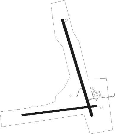
Runway info
Runway 1 / 19  | ||
| length | 1220m (4003ft) | |
| bearing | 342° / 162° | |
| width | 30m (100ft) | |
| surface | asphalt | |
| Runway 11 / 29 | ||
| length | 917m (3009ft) | |
| bearing | 88° / 268° | |
| width | 23m (75ft) | |
| surface | asphalt | |
| displ threshold | 0m (0ft) / 121m (397ft) | |
| blast zone | 0m (0ft) / 113m (371ft) | |
Nearby beacons
| code | identifier | dist | bearing | frequency |
|---|---|---|---|---|
| PQI | PRESQUE ISLE VOR/DME | 6.6 | 218° | 116.40 |
| HUL | DME | 50.5 | 168° | 116.10 |
Instrument approach procedures
| runway | airway (heading) | route (dist, bearing) |
|---|---|---|
| RW01 | HOXEB (341°) | HOXEB 3700ft |
| RNAV | HOXEB 3700ft UKOYO (6mi, 342°) 2300ft OKOKE (3mi, 342°) 1480ft KCAR (3mi, 339°) 654ft (4515mi, 125°) 870ft AKYAK (4521mi, 305°) 3000ft AKYAK (turn) | |
| RW19 | AKYAK (162°) | AKYAK 3000ft |
| RW19 | IPESE (127°) | IPESE AKYAK (7mi, 81°) 3000ft |
| RW19 | JEGUB (205°) | JEGUB AKYAK (7mi, 261°) 3000ft |
| RNAV | AKYAK 3000ft ULOVY (6mi, 162°) 2500ft IKAVE (3mi, 162°) 1420ft KCAR (3mi, 164°) 657ft (4515mi, 125°) 1300ft AKYAK (4521mi, 305°) 3000ft AKYAK (turn) |
Disclaimer
The information on this website is not for real aviation. Use this data with the X-Plane flight simulator only! Data taken with kind consent from X-Plane 12 source code and data files. Content is subject to change without notice.