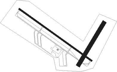
Willmar Muni
Airport details
| Country | United States of America |
| State | Minnesota |
| Region | K3 |
| Airspace | Minneapolis Ctr |
| Municipality | Willmar |
| Elevation | 1125ft (343m) |
| Timezone | GMT -6 |
| Coordinates | 45.11703, -95.12933 |
| Magnetic var | |
| Type | land |
| Available since | X-Plane v10.40 |
| ICAO code | KBDH |
| IATA code | n/a |
| FAA code | n/a |
Communication
| Willmar Muni UNICOM | 122.800 |
Approach frequencies
| ILS-cat-I | RW13 | 109.5 | 18.00mi |
| 3° GS | RW13 | 109.5 | 18.00mi |
Nearby beacons
| code | identifier | dist | bearing | frequency |
|---|---|---|---|---|
| BDH | WILLMAR VOR/DME | 0.1 | 74° | 113.70 |
| MVE | MONTEVIDEO VOR/DME | 26.2 | 256° | 111.60 |
| DWN | DARWIN VORTAC | 28.6 | 93° | 109 |
| RWF | REDWOOD FALLS VOR/DME | 39 | 180° | 113.30 |
| MOX | MORRIS VOR/DME | 44.5 | 298° | 109.60 |
| GB | GARNO (MARSHALL) NDB | 49.7 | 232° | 253 |
| MML | MARSHALL VOR/DME | 49.9 | 226° | 111 |
| AXN | ALEXANDRIA VOR/DME | 50.7 | 353° | 112.80 |
| XCR | RIPLEY NDB | 66.5 | 39° | 404 |
Instrument approach procedures
| runway | airway (heading) | route (dist, bearing) |
|---|---|---|
| RW13 | ARDUE (83°) | ARDUE IBIYO (14mi, 64°) 2800ft BEESE (5mi, 49°) 2800ft |
| RW13 | ARMUW (168°) | ARMUW SWELT (9mi, 209°) 2900ft BEESE (5mi, 230°) 2800ft |
| RW13 | BEESE (120°) | BEESE 2800ft |
| RW13 | CLAPS (73°) | CLAPS IBIYO (8mi, 321°) 2800ft BEESE (5mi, 49°) 2800ft |
| RNAV | BEESE 2800ft LOPOW (6mi, 120°) 2800ft KBDH (6mi, 120°) 1176ft (5622mi, 115°) 1387ft HEPIV (5614mi, 295°) 2800ft HEPIV (turn) | |
| RW31 | ARMUW (168°) | ARMUW HEPIV (30mi, 149°) 3100ft HEPIV (turn) 2800ft |
| RW31 | CLAPS (73°) | CLAPS HEPIV (18mi, 99°) 2800ft HEPIV (turn) 2800ft |
| RW31 | DWN (273°) | DWN HEPIV (21mi, 258°) 2800ft |
| RW31 | RWF (360°) | RWF HEPIV (33mi, 22°) 2800ft |
| RNAV | HEPIV 2800ft FIKIG (6mi, 301°) 2800ft ZONUL (3mi, 301°) 1680ft KBDH (2mi, 302°) 1175ft (5622mi, 115°) 1326ft BEESE (5631mi, 295°) 2800ft BEESE (turn) |
Disclaimer
The information on this website is not for real aviation. Use this data with the X-Plane flight simulator only! Data taken with kind consent from X-Plane 12 source code and data files. Content is subject to change without notice.

