Mount Carmel - Mt Carmel Muni
Airport details
| Country | United States of America |
| State | Illinois |
| Region | K5 |
| Airspace | Indianapolis Ctr |
| Municipality | Lawrence County |
| Elevation | 429ft (131m) |
| Timezone | GMT -6 |
| Coordinates | 38.60653, -87.72669 |
| Magnetic var | |
| Type | land |
| Available since | X-Plane v10.40 |
| ICAO code | KAJG |
| IATA code | n/a |
| FAA code | AJG |
Communication
| Mt Carmel Muni AWOS 3 | 134.900 |
| Mt Carmel Muni CTAF/UNICOM | 122.700 |
| Mt Carmel Muni EVANSVILLE Approach/Departure | 125.600 |
Nearby Points of Interest:
Bridge at Thirteenth Street
-Lawrence County Courthouse
-Forts of Vincennes, Indiana
-St. Francis Xavier Cathedral and Library
-Old State Bank
-Vincennes Fortnightly Club
-Grouseland
-Hack and Simon Office Building
-Pyramid Mound
-Kimmell Park
-Beall-Orr House
-Lyles Consolidated School
-Shadowwood
-Enoco Coal Mine
-Gibson County Courthouse
-Welborn-Ross House
-Trippett-Glaze-Duncan-Kolb Farm
-Swan Island Site
-Larchmound
-Olney Carnegie Library
-Ambrose Hopkinson House
-Andrew Nicholson Farmstead
-Pike County Courthouse
-Patoka Bridges Historic District
-American Trust and Savings Bank
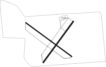
Runway info
Runway 13 / 31  | ||
| length | 1373m (4505ft) | |
| bearing | 124° / 304° | |
| width | 23m (75ft) | |
| surface | asphalt | |
| Runway 4 / 22 | ||
| length | 1219m (3999ft) | |
| bearing | 48° / 228° | |
| width | 30m (100ft) | |
| surface | asphalt | |
| blast zone | 0m (0ft) / 152m (499ft) | |
Nearby beacons
| code | identifier | dist | bearing | frequency |
|---|---|---|---|---|
| LWV | DME | 11.3 | 37° | 108.80 |
| SAM | SAMSVILLE VOR/DME | 18.3 | 251° | 116.60 |
| OLY | OLNEY NDB | 21.9 | 284° | 272 |
| PLX | PALESTINE (ROBINSON) NDB | 24.8 | 12° | 391 |
| EVV | VICCI (EVANSVILLE) NDB | 31.8 | 149° | 219 |
| FWC | WAYNE CO (FAIRFIELD) NDB | 34.8 | 252° | 257 |
| BIB | BIBLE GROVE VORTAC | 40 | 293° | 109 |
| PXV | POCKET CITY (EVANSVILLE) VORTAC | 40.7 | 183° | 113.30 |
| HU | YINNO (TERRE HAUTE) NDB | 49.3 | 23° | 245 |
| TTH | TERRE HAUTE VORTAC | 57.4 | 28° | 115.30 |
| OWB | OWENSBORO VOR/DME | 58.1 | 147° | 108.60 |
| MTO | DME | 58.4 | 327° | 109.40 |
Instrument approach procedures
| runway | airway (heading) | route (dist, bearing) |
|---|---|---|
| RW04 | SURDY (47°) | SURDY 2500ft |
| RNAV | SURDY 2500ft POLNE (6mi, 48°) 2100ft QUIRE (2mi, 48°) 1300ft KAJG (3mi, 46°) 468ft (5298mi, 114°) 829ft RUOFF (5291mi, 294°) 2500ft RUOFF (turn) | |
| RW22 | LISLE (219°) | LISLE RUOFF (21mi, 214°) 2500ft |
| RW22 | RUOFF (228°) | RUOFF 2500ft |
| RNAV | RUOFF 2500ft HEGSI (6mi, 228°) 2100ft ZALRA (2mi, 228°) 1300ft KAJG (3mi, 229°) 469ft (5298mi, 114°) 679ft SURDY (5306mi, 294°) 2500ft SURDY (turn) | |
| RW31 | CLOWN (282°) | CLOWN NIYRI (10mi, 259°) 2500ft |
| RW31 | NIYRI (304°) | NIYRI 2500ft |
| RW31 | PRINC (338°) | PRINC NIYRI (10mi, 26°) 2500ft |
| RNAV | NIYRI 2500ft JIPGA (6mi, 304°) 2100ft KAJG (5mi, 304°) 474ft (5298mi, 114°) 829ft NIYRI (5290mi, 294°) 2500ft NIYRI (turn) |
Disclaimer
The information on this website is not for real aviation. Use this data with the X-Plane flight simulator only! Data taken with kind consent from X-Plane 12 source code and data files. Content is subject to change without notice.