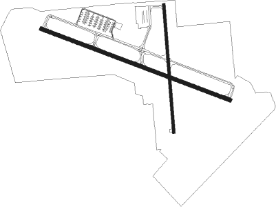
Anderson - Anderson Muni Darlington Fld
Airport details
| Country | United States of America |
| State | Indiana |
| Region | K5 |
| Airspace | Indianapolis Ctr |
| Municipality | Anderson |
| Elevation | 917ft (280m) |
| Timezone | GMT -5 |
| Coordinates | 40.10861, -85.61300 |
| Magnetic var | |
| Type | land |
| Available since | X-Plane v10.40 |
| ICAO code | KAID |
| IATA code | AID |
| FAA code | AID |
Communication
| Anderson Muni Darlington Fld AWOS 3 | 128.550 |
| Anderson Muni Darlington Fld CTAF | 126.000 |
| Anderson Muni Darlington Fld UNICOM | 122.950 |
| Anderson Muni Darlington Fld Ground Control | 121.600 |
| Anderson Muni Darlington Fld Tower | 126.000 |
| Anderson Muni Darlington Fld IND Approach/Departure | 120.650 |
Approach frequencies
| ILS-cat-I | RW30 | 110.1 | 18.00mi |
| 3° GS | RW30 | 110.1 | 18.00mi |
Nearby beacons
| code | identifier | dist | bearing | frequency |
|---|---|---|---|---|
| AI | VIDEO (ANDERSON) NDB | 5.2 | 111° | 394 |
| MIE | MUNCIE VOR/DME | 12.6 | 60° | 114.40 |
| JN | BALLL (MUNCIE) NDB | 14 | 76° | 365 |
| MI | BALLL (MUNCIE) NDB | 14.1 | 76° | 365 |
| UWL | NEW CASTLE NDB | 19.2 | 128° | 385 |
| UMP | METROPOLITAN (INDIANAPOLIS) NDB | 22.5 | 249° | 338 |
| MZZ | MARION VOR/DME | 23.3 | 350° | 108.60 |
| SQ | PNTHR (CONNERSVILLE) NDB | 29.8 | 124° | 227 |
| SHB | SHELBYVILLE VOR/DME | 30.2 | 204° | 112 |
| AWW | WINCHESTER NDB | 31.9 | 85° | 212 |
| OKK | KOKOMO VORTAC | 32.3 | 313° | 113.50 |
| FV | LAREZ (INDIANAPOLIS) NDB | 33.1 | 241° | 349 |
| CO | COLFA (INDIANAPOLIS) NDB | 37.8 | 232° | 232 |
| VHP | BRICKYARD VORTAC | 38.9 | 249° | 116.30 |
| GUS | GRISSOM (PERU) VORTAC | 40.5 | 315° | 108.45 |
| RID | RICHMOND VOR/DME | 41.4 | 115° | 110.60 |
| BA | CLIFS (COLUMBUS) NDB | 48.1 | 195° | 410 |
| HLB | BATESVILLE NDB | 48.6 | 155° | 254 |
| FWA | FORT WAYNE VORTAC | 55.7 | 26° | 117.80 |
Instrument approach procedures
| runway | airway (heading) | route (dist, bearing) |
|---|---|---|
| RW12 | MZZ (170°) | MZZ WARMU (20mi, 209°) 2900ft |
| RW12 | WARMU (110°) | WARMU 2900ft |
| RW12 | WELDO (90°) | WELDO WARMU (12mi, 69°) 2900ft |
| RNAV | WARMU 2900ft HIBOX (5mi, 110°) 2800ft KAID (6mi, 110°) 925ft (5204mi, 115°) 1157ft NOMUF (5193mi, 295°) 3000ft NOMUF (turn) | |
| RW30 | MOTTS (286°) | MOTTS NOMUF (15mi, 283°) 3000ft |
| RW30 | NEWTO (324°) | NEWTO NOMUF (8mi, 37°) 3000ft |
| RW30 | NOMUF (290°) | NOMUF 3000ft |
| RW30 | OCOVE (261°) | OCOVE NOMUF (9mi, 212°) 3000ft |
| RNAV | NOMUF 3000ft HELAG (6mi, 290°) 2700ft STOWA (3mi, 290°) 1600ft KAID (2mi, 290°) 967ft WARMU (12mi, 290°) 3000ft WARMU (turn) |
Disclaimer
The information on this website is not for real aviation. Use this data with the X-Plane flight simulator only! Data taken with kind consent from X-Plane 12 source code and data files. Content is subject to change without notice.

