Waseca - Waseca Muni
Airport details
| Country | United States of America |
| State | Minnesota |
| Region | K3 |
| Airspace | Minneapolis Ctr |
| Municipality | Waseca County |
| Elevation | 1125ft (343m) |
| Timezone | GMT -6 |
| Coordinates | 44.07346, -93.55295 |
| Magnetic var | |
| Type | land |
| Available since | X-Plane v10.40 |
| ICAO code | KACQ |
| IATA code | n/a |
| FAA code | ACQ |
Communication
| Waseca Muni CTAF/UNICOM | 122.800 |
Nearby Points of Interest:
W. J. Armstrong Company Wholesale Grocers Building
-Waseca County Courthouse
-Philo C. Bailey House
-William R. Wolf House
-Roscoe P. Ward House
-Vista Lutheran Church
-Strangers Refuge Lodge Number 74, IOOF
-Minnesota State Public School for Dependent and Neglected Children
-Owatonna Commercial Historic District
-Owatonna City and Firemen's Hall
-Steele County Courthouse
-Owatonna Public Library
-Dr. John H. Adair House
-Pillsbury Baptist Bible College
-Ezra Abbott House
-Thomas Scott Buckham Memorial Library
-Faribault City Hall
-Rice County Courthouse and Jail
-Batchelder's Block
-Faribault Viaduct
-Blind Department Building and Dow Hall, State School for the Blind
-Timothy J. McCarthy Building
-Thomas and Bridget Shanahan McMahon House
-Faribault Woolen Mills
-Shattuck-Saint Mary's
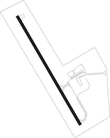
Runway info
| Runway 15 / 33 | ||
| length | 1036m (3399ft) | |
| bearing | 146° / 326° | |
| width | 23m (75ft) | |
| surface | asphalt | |
Nearby beacons
| code | identifier | dist | bearing | frequency |
|---|---|---|---|---|
| FOW | HALFWAY (MORRISTOWN) VOR/DME | 11.1 | 54° | 111.20 |
| OW | TONNA (OWATONNA) NDB | 17.1 | 90° | 379 |
| MKT | MANKATO VOR/DME | 17.8 | 292° | 110.80 |
| AEL | ALBERT LEA VOR/DME | 24.8 | 155° | 109.80 |
| FGT | FARMINGTON VORTAC | 37 | 34° | 115.70 |
| JAY | AUSTIN VOR/DME | 40.5 | 128° | 108.20 |
| FQ | MONTZ (FAIRMONT) NDB | 44.7 | 237° | 420 |
| RST | ROCHESTER VOR/DME | 44.8 | 107° | 112 |
| FCM | FLYING CLOUD (MINNEAPOLIS VOR/DME | 45.4 | 8° | 117.70 |
| FNX | DME | 45.5 | 243° | 114.25 |
| FRM | DME | 45.5 | 244° | 110.20 |
| RG | REGUE (RED WING) NDB | 50 | 60° | 274 |
| MSP | MINNEAPOLIS VOR/DME | 51.2 | 21° | 115.30 |
| MCW | MASON CITY VOR/DME | 59.5 | 167° | 114.90 |
| IY | CHUKK (CHARLES CITY) NDB | 66.8 | 139° | 417 |
Instrument approach procedures
| runway | airway (heading) | route (dist, bearing) |
|---|---|---|
| RW15 | MKT (112°) | MKT WITUD (11mi, 85°) 3000ft |
| RW15 | PRAGS (187°) | PRAGS WITUD (18mi, 211°) 3000ft |
| RW15 | WITUD (146°) | WITUD 3000ft |
| RNAV | WITUD 3000ft VIBUC (6mi, 146°) 2700ft UBEYI (3mi, 146°) 1700ft KACQ (2mi, 146°) 1167ft (5558mi, 115°) 1377ft VUYUN (5554mi, 295°) 3000ft VUYUN (turn) | |
| RW33 | FREED (351°) | FREED VUYUN (11mi, 16°) 3000ft |
| RW33 | NEWRY (320°) | NEWRY VUYUN (13mi, 315°) 3000ft |
| RW33 | VUYUN (326°) | VUYUN 3000ft |
| RNAV | VUYUN 3000ft OSMAE (6mi, 326°) 2700ft EYOTI (3mi, 326°) 1660ft KACQ (2mi, 326°) 1169ft WITUD (11mi, 326°) 3000ft WITUD (turn) |
Disclaimer
The information on this website is not for real aviation. Use this data with the X-Plane flight simulator only! Data taken with kind consent from X-Plane 12 source code and data files. Content is subject to change without notice.