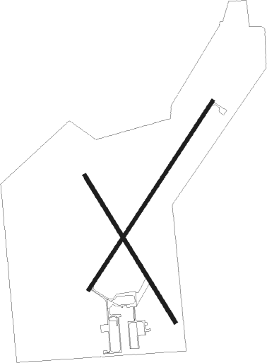
Paola - Miami Co
Airport details
| Country | United States of America |
| State | Kansas |
| Region | K3 |
| Airspace | Kansas City Ctr |
| Municipality | Miami County |
| Elevation | 937ft (286m) |
| Timezone | GMT -6 |
| Coordinates | 38.54022, -94.92014 |
| Magnetic var | |
| Type | land |
| Available since | X-Plane v10.40 |
| ICAO code | K81 |
| IATA code | n/a |
| FAA code | n/a |
Communication
| Miami Co CTAF/UNICOM | 122.800 |
| Miami Co KANSAS CITY Approach/Departure | 118.900 |
Nearby Points of Interest:
Miami County Courthouse
-John Brown Museum State Historic Site
-Carey’s Ford Bridge
-William Thomas Turner Barn
-Ottawa Library
-Dietrich Cabin
-Franklin County Courthouse
-Ottawa High School and Junior High School
-Albert Ott House
-Franklin R. Lanter House
-Martin Van Buren Parker House
-I. O. Pickering House
-Anderson County Courthouse
-Vinland Grange Hall
-Vinland Presbyterian Church
-Mahaffie House
-Linn County Courthouse
-Mine Creek Bridge
-Haskell-Baker Wetlands
-Harrisonville Courthouse Square Historic District
-Harry S. Truman National Historic Site
-Spooner Hall
-United Presbyterian Center
-Granada Theater
-Strong Hall

Nearby beacons
| code | identifier | dist | bearing | frequency |
|---|---|---|---|---|
| PK | HERBB (OLATHE) NDB | 15.4 | 41° | 420 |
| OWI | OTTAWA NDB | 15.7 | 270° | 251 |
| JZ | NEWBN (LAWRENCE) NDB | 24.9 | 328° | 338 |
| BUM | BUTLER VORTAC | 25.9 | 122° | 115.90 |
| FOE | FORBES (TOPEKA) TACAN | 42.4 | 299° | 111.60 |
| MCI | KANSAS CITY VORTAC | 45.5 | 14° | 113.25 |
| RN | HUGGY (KANSAS CITY) NDB | 45.8 | 5° | 416 |
| TOP | TOPEKA VORTAC | 46.3 | 313° | 117.80 |
| ANX | NAPOLEON VORTAC | 49.8 | 55° | 114 |
| TO | BILOY (TOPEKA) NDB | 50 | 307° | 521 |
| CNU | CHANUTE VOR/DME | 63.4 | 216° | 109.20 |
Instrument approach procedures
| runway | airway (heading) | route (dist, bearing) |
|---|---|---|
| RW03 | KUVEY (45°) | KUVEY 3100ft |
| RNAV | KUVEY 3100ft COPAC (7mi, 45°) 2600ft K81 (5mi, 45°) 979ft (5636mi, 112°) 1272ft SOKYO (5628mi, 292°) 3100ft SOKYO (turn) | |
| RW21 | SOKYO (225°) | SOKYO 3100ft |
| RNAV | SOKYO 3100ft ROKSE (7mi, 225°) 2600ft K81 (5mi, 225°) 981ft (5636mi, 112°) 1252ft KUVEY (5644mi, 292°) 3100ft KUVEY (turn) |
Disclaimer
The information on this website is not for real aviation. Use this data with the X-Plane flight simulator only! Data taken with kind consent from X-Plane 12 source code and data files. Content is subject to change without notice.