Tzaneen
Airport details
| Country | South Africa |
| State | Limpopo |
| Region | FA |
| Airspace | Johannesburg Ctr |
| Municipality | Greater Tzaneen Local Municipality |
| Elevation | 1914ft (583m) |
| Timezone | GMT +2 |
| Coordinates | -23.83000, 30.31667 |
| Magnetic var | |
| Type | land |
| Available since | X-Plane v10.40 |
| ICAO code | FATZ |
| IATA code | LTA |
| FAA code | n/a |
Communication
| Tzaneen CTAF | 124.800 |
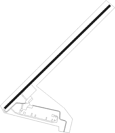
Runway info
| Runway 06 / 24 | ||
| length | 1440m (4724ft) | |
| bearing | 53° / 233° | |
| width | 20m (66ft) | |
| surface | asphalt | |
Nearby beacons
| code | identifier | dist | bearing | frequency |
|---|---|---|---|---|
| TZ | TZANEEN NDB | 2.9 | 58° | 212 |
| TOY | THOHOYANDOU NDB | 45.3 | 360° | 285 |
| PHV | PHALABORWA VOR | 46 | 95° | 115.30 |
| PPV | POLOKWANE VOR/DME | 47 | 269° | 114.50 |
| HA | HOEDSPRUIT NDB | 49.8 | 125° | 265 |
| HSV | HOEDSPRUIT VOR/DME | 50.7 | 125° | 114 |
| THO | THOHOYANDOU NDB | 52.6 | 11° | 325 |
| LO | LOUIS TRICHARDT NDB | 52.9 | 328° | 457 |
| LTV | MAKHADO VOR/DME | 53.2 | 317° | 115 |
| VLH | VAALHOEK NDB | 62.6 | 154° | 390 |
Disclaimer
The information on this website is not for real aviation. Use this data with the X-Plane flight simulator only! Data taken with kind consent from X-Plane 12 source code and data files. Content is subject to change without notice.