Carrizozo - Carrizozo Municipal Airport
Airport details
| Country | United States of America |
| State | New Mexico |
| Region | K2 |
| Airspace | Albuquerque Ctr |
| Municipality | Carrizozo |
| Elevation | 5370ft (1637m) |
| Timezone | GMT -7 |
| Coordinates | 33.64890, -105.89622 |
| Magnetic var | |
| Type | land |
| Available since | X-Plane v10.40 |
| ICAO code | F37 |
| IATA code | n/a |
| FAA code | n/a |
Communication
| Carrizozo Municipal Airport CTAF | 122.800 |
Nearby Points of Interest:
Jicarilla Schoolhouse
-Lincoln Historic District
-Peter and Henriette Wyeth Hurd House
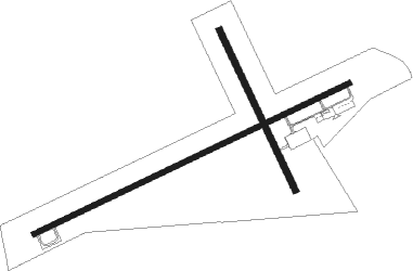
Runway info
Runway 6 / 24  | ||
| length | 1506m (4941ft) | |
| bearing | 72° / 252° | |
| width | 23m (75ft) | |
| surface | asphalt | |
| Runway 15 / 33 | ||
| length | 764m (2507ft) | |
| bearing | 156° / 336° | |
| width | 27m (89ft) | |
| surface | dirt | |
Nearby beacons
| code | identifier | dist | bearing | frequency |
|---|---|---|---|---|
| CEP | CAPITAN (RUIDOSO) NDB | 26.4 | 108° | 278 |
| CNX | CORONA VORTAC | 44.4 | 17° | 115.50 |
| HMN | HOLLOMAN (ALAMOGORDO) TACAN | 48.4 | 195° | 114.50 |
| BWS | (ALAMOGORDO) DME | 50 | 188° | 109.60 |
| ONM | SOCORRO VORTAC | 61.9 | 307° | 116.80 |
Disclaimer
The information on this website is not for real aviation. Use this data with the X-Plane flight simulator only! Data taken with kind consent from X-Plane 12 source code and data files. Content is subject to change without notice.